Printable Version of Topic
Click here to view this topic in its original format
City by the Lake.org, The Voice of Michigan City, Indiana _ City Talk _ Winter Weather thread 2013-14
Posted by: Southsider2k12 Oct 21 2013, 07:45 AM
Looks like we are trying to go straight into winter mode for the weather. The temp right now is the highest it is expected to get for the entire week. We do have a freeze warning out for tonight, so if you have plants outside, it is time to bring them in. We also could see the dreaded four letter s-word for the first time of the season tonight into tomorrow morning, though no accumulation is expected.
Posted by: diggler Oct 21 2013, 10:41 AM
Should help kill off the growing West Nile Virus squito threat in the area.
Posted by: ChickenCityRoller Oct 21 2013, 11:25 AM
interesting info here http://www.cdc.gov/westnile/statsMaps/finalMapsData/index.html
the numbers go up and down with seemingly no pattern. I figured last year would have been very low due to the drought like conditions we had. Suprisingly, last year was very high.
Posted by: Southsider2k12 Oct 21 2013, 06:33 PM
NOw changed to a freeze warning tonight. Ugh.
Posted by: diggler Oct 22 2013, 07:20 AM

NOw changed to a freeze warning tonight. Ugh.
So that means we get to enjoy Indian Summer next week.
Posted by: diggler Oct 24 2013, 11:19 AM
Snowed in Westville this morning, and now the sun is out like if nothing ever happened.
Posted by: ChickenCityRoller Oct 24 2013, 11:26 AM
I blew out my outdoor water spigots yesterday. Bring on the freeze!
Posted by: Southsider2k12 Oct 24 2013, 11:52 AM
I blew out my outdoor water spigots yesterday. Bring on the freeze!
I drained my hoses on Tuesday morning. So depressing.
Posted by: diggler Oct 27 2013, 02:42 PM
Cut the grass for the final time, and stowed the mower for the season. Still have a few tomatoes to harvest though.
Posted by: Southsider2k12 Oct 30 2013, 01:34 PM
Calling for 1-2 inches of rain and possible T-storms tomorrow. Could be interesting.
Posted by: Southsider2k12 Oct 30 2013, 06:40 PM
Sklilling has City predicted for 3.93 inches of rain over the next 24-36 hours. Let's just be happy it isn't 28 degrees outside.
Posted by: mcstumper Nov 11 2013, 09:36 AM
http://blog.chicagoweathercenter.com/2013/11/10/wintry-tease-to-be-followed-by-big-warm-up/
http://www.wunderground.com/q/zmw:46360.1.99999.html#warn
Up to 7 inches of snow by tomorrow.
Posted by: Southsider2k12 Nov 11 2013, 10:15 AM
Playing amatuer forecaster, I think the 5-9 inch projection for us is going to be very wrong as long as the wind directions being predicted are accurate. We are going to go from a west wind to a north wind as the day goes by. That will get us into a couple of bands. The winds are supposed to hold today and tonight at straight north, which probably means the snow band forecasts are aimed about 20 miles too far East. I'd be more worried if I were Valpo, Portage, Gary etc. If the winds hold up, I think we end up in the 1-3 inch range.
Posted by: diggler Nov 11 2013, 11:16 AM
Even if we do get a half foot of snow tomorrow, it will all be gone this weekend with temps in the 60s.
Posted by: Ang Nov 12 2013, 10:37 AM
LaPorte was a mess this morning! What a harrowing drive in to work. There was at least six inches on my car this morning, maybe more. And LP schools closed. First they had a two-hour delay, then decided to close.
Posted by: diggler Nov 12 2013, 11:21 AM

Already stopped snowing in Westville with maybe an inch or two on the ground. Looks like all the action was east of me today.
Posted by: diggler Nov 12 2013, 12:40 PM
Lake effect snow piles up in the Michiana snowbelt; I-94 at a standstill
Posted on: November 12th, 2013 9:58 AM by Mike Hamernik
Over a foot of lake effect snow fell overnight just 60 miles from downtown Chicago. Persistent heavy snow piled up within a narrow corridor in Berrien and LaPorte Counties, where 14" of new snow accumulation was reported at St. Joseph, Michigan.
The snow is affecting travel in area. At 8:50AM, Eastbound Interstate 94 is at a standstill near Stevensville, Michigan due to snow, limited visibility and several weather related accidents.
A Lake Effect Snow Warning remains in effect until 1PM EST for LaPorte and Berrien Counties.
A Lake Effect Snow Advisory is in effect until 1PM EST for St. Joseph (IN), Porter and Jasper Counties.
Here are a few of the latest snowfall reports as of 8:30AM:
14.0" St. Joseph, MI
13.0" Stevensville, MI (3mi NNE)
12.0" Stevensville, MI
9.0" Kingsbury, IN
8.0" Berrien Springs, MI
7.5" Wanahah, IN
7.4" La Porte, IN (1.6mi SW)
7.0" Kingsford Heights, IN
6.0" La Porte, IN (1.3mi SSW)
4.0" Westville, IN
4.0" Buchanan, MI
1.0" Valparaiso, IN
BELOW: A buried snow fence on Silver Beach in St. Joseph, Michigan indicates snow drifts may be several feet deep.
Posted by: diggler Nov 23 2013, 12:25 PM
Boy is it ever WINTRY out there today ! Wonder how many fans will show up at Notre Dame Stadium this afternoon.
Posted by: Southsider2k12 Nov 25 2013, 11:38 AM
From ALCO
We're waiting on the Hazardous Weather Outlook for this weather zone. The Chicago Weather office has indicated it expects a significant snow event for Porter County and eastern Lake County.
It looks like LaPorte County will easily see more than seven inches of snow out of this and it could be a lot more in localized areas.
Posted by: diggler Nov 25 2013, 12:26 PM
Looks like the makings of an early winter weather wallop around these parts. One can only guess what January and February may eventually look like.
Posted by: Southsider2k12 Nov 25 2013, 03:07 PM
The Watch has been issued for tomorrow night...
Lake Effect Snow Watch for La Porte, IN
From 11:00 PM CST, Tue., Nov 26, 2013 until 6:00 PM CST, Wed., Nov 27, 2013
Other affected areas:
…
La Porte, IN; St. Joseph, IN; Starke, IN; Pulaski, IN; Marshall, IN; Fulton, IN; Berrien, MI
Issued by The National Weather Service
North Webster, IN
Mon, Nov 25, 2013, 2:54 PM CST
Updated Nov 25, 2013, 2:55pm CST
... LAKE EFFECT SNOW WATCH IN EFFECT FROM LATE TUESDAY NIGHT THROUGH WEDNESDAY EVENING...
THE NATIONAL WEATHER SERVICE IN NORTHERN INDIANA HAS ISSUED A LAKE EFFECT SNOW WATCH... WHICH IS IN EFFECT FROM LATE TUESDAY NIGHT THROUGH WEDNESDAY EVENING.
HAZARDOUS WEATHER...
* LAKE EFFECT SNOW IS EXPECTED TO DEVELOP BY LATE EVENING TUESDAY NIGHT AND INTENSIFY SIGNIFICANTLY TOWARD DAYBREAK WEDNESDAY. SNOWFALL RATES OF 1 TO 2 INCHES PER HOUR WITH SNOWFALL TOTALS OF 6 TO 12 INCHES POSSIBLE WITHIN THE WATCH AREA. LOCALLY HIGHER AMOUNTS ARE POSSIBLE IF BANDS PERSIST.
* NORTHWEST WINDS OF 15 TO 25 MPH WILL LEAD TO AREAS OF BLOWING AND DRIFTING.
IMPACTS...
* HOLIDAY TRAVELERS SHOULD PLAN ON ENCOUNTERING HAZARDOUS WINTER DRIVING CONDITIONS ALONG PORTIONS OF US 30... INTERSTATE 94 AND THE TOLL ROAD OVER NORTHWEST INDIANA AND SOUTHWEST MICHIGAN ON WEDNESDAY.
* VISIBILITIES MAY BE REDUCED TO NEAR ZERO AT TIMES IN HEAVY LAKE EFFECT SNOW. DRIVERS MAY EXPERIENCE SUDDEN REDUCTIONS IN VISIBILITIES AND DETERIORATING DRIVING CONDITIONS.
PRECAUTIONARY/PREPAREDNESS ACTIONS...
A LAKE EFFECT SNOW WATCH MEANS THERE IS A POTENTIAL FOR A LARGE AMOUNT OF SNOW IN ONLY A FEW HOURS. VISIBILITIES AND DEPTH OF SNOW CAN VARY GREATLY... IMPACTING TRAVEL SIGNIFICANTLY. CONTINUE TO MONITOR THE LATEST FORECASTS.
... SIGNIFICANT LAKE EFFECT SNOW POSSIBLE TUESDAY NIGHT AND WEDNESDAY...
.A DEEPENING AREA OF LOW PRESSURE LIFTING UP ALONG THE EAST COAST ON TUESDAY WILL ALLOW FOR ANOTHER SURGE OF COLD AIR TO FUNNEL SOUTHWARD ACROSS THE WESTERN GREAT LAKES TUESDAY AND WEDNESDAY. DEEP NORTHERLY FLOW ALONG THE FULL LENGTH OF LAKE MICHIGAN COMBINED WITH ADDITIONAL MOISTURE FROM LAKE SUPERIOR IS EXPECTED TO RESULT IN HEAVY LAKE EFFECT SNOW BANDS OVER NORTHWEST INDIANA AND EXTREME SOUTHWEST MICHIGAN LATE TUESDAY NIGHT THROUGH LATE WEDNESDAY AFTERNOON.
UNCERTAINTIES TIED TO THE LOCATION AND PERSISTENCE OF THE HEAVIEST SNOW REMAIN. STAY TUNED FOR LATER FORECASTS AND BE PREPARED FOR SEVERE WINTER WEATHER CONDITIONS SHOULD THEY DEVELOP.
Posted by: diggler Nov 25 2013, 05:07 PM
Can you friggin BELIEVE THIS ?? Gotta get the blower ready.
_
Posted by: Southsider2k12 Nov 26 2013, 07:00 AM
"The Watch" is now "The Warning".
Lake Effect Snow Warning for La Porte, IN
From 11:00 PM CST, Tue., Nov 26, 2013 until 11:00 PM CST, Wed., Nov 27, 2013
Other affected areas:
…
La Porte, IN; Berrien, MI
Issued by The National Weather Service
North Webster, IN
Tue, Nov 26, 2013, 3:14 AM CST
Local Radar Map
Updated Nov 26, 2013, 6:45am CST
... LAKE EFFECT SNOW WARNING IN EFFECT FROM MIDNIGHT EST /11 PM CST/ TONIGHT TO MIDNIGHT EST /11 PM CST/ WEDNESDAY NIGHT...
THE NATIONAL WEATHER SERVICE IN NORTHERN INDIANA HAS ISSUED A LAKE EFFECT SNOW WARNING... WHICH IS IN EFFECT FROM MIDNIGHT EST /11 PM CST/ TONIGHT TO MIDNIGHT EST /11 PM CST/ WEDNESDAY NIGHT. THE LAKE EFFECT SNOW WATCH IS NO LONGER IN EFFECT.
HAZARDOUS WEATHER...
* TIMING... LAKE EFFECT SNOW IS EXPECTED TO DEVELOP THIS EVENING AND INTENSIFY SIGNIFICANTLY LATE TONIGHT INTO WEDNESDAY. LAKE EFFECT SNOW WILL RAPIDLY DECREASE IN INTENSITY AND COVERAGE WEDNESDAY NIGHT.
* SNOW ACCUMULATIONS... 6 TO 12 INCHES EXPECTED... WITH SNOWFALL RATES OF 1 TO 2 INCHES PER HOUR. LOCALLY HIGHER AMOUNTS ARE POSSIBLE IF BANDS PERSIST ACROSS FAR SOUTHWEST BERRIEN COUNTY INTO NORTHERN LA PORTE COUNTY.
* OTHER IMPACTS... NORTHWEST WINDS OF 15 TO 25 MPH WILL LEAD TO AREAS OF BLOWING AND DRIFTING.
IMPACTS...
* HOLIDAY TRAVELERS SHOULD PLAN ON ENCOUNTERING HAZARDOUS WINTER DRIVING CONDITIONS ALONG PORTIONS OF US 30... INTERSTATE 94 AND THE TOLL ROAD OVER NORTHWEST INDIANA AND SOUTHWEST MICHIGAN ON WEDNESDAY.
* VISIBILITIES MAY BE REDUCED TO NEAR ZERO AT TIMES IN HEAVY LAKE EFFECT SNOW. DRIVERS MAY EXPERIENCE SUDDEN REDUCTIONS IN VISIBILITIES AND DETERIORATING DRIVING CONDITIONS.
PRECAUTIONARY/PREPAREDNESS ACTIONS...
A LAKE EFFECT SNOW WARNING MEANS SIGNIFICANT AMOUNTS OF LAKE- EFFECT SNOW ARE FORECAST THAT WILL MAKE TRAVEL VERY HAZARDOUS OR IMPOSSIBLE. LAKE-EFFECT SNOW SHOWERS TYPICALLY ALIGN THEMSELVES IN BANDS AND WILL LIKELY BE INTENSE ENOUGH TO DROP 1 TO SEVERAL INCHES OF SNOW PER HOUR FOR SEVERAL HOURS. VISIBILITIES VARY GREATLY AND CAN DROP TO ZERO WITHIN MINUTES. TRAVEL IS STRONGLY DISCOURAGED. COMMERCE COULD BE SEVERELY IMPACTED. IF YOU MUST TRAVEL... KEEP AN EXTRA FLASHLIGHT... FOOD... AND WATER IN YOUR VEHICLE IN CASE OF AN EMERGENCY.
... HEAVY LAKE EFFECT SNOW EXPECTED LATER TONIGHT THROUGH WEDNESDAY EVENING...
.MODERATE TO HEAVY LAKE EFFECT SNOW BANDS ARE EXPECTED TO ORGANIZE ACROSS NORTHWEST INDIANA AND FAR SOUTHWEST LOWER MICHIGAN LATER TONIGHT INTO WEDNESDAY... BEFORE DIMINISHING IN COVERAGE AND INTENSITY WEDNESDAY EVENING. THE HEAVIEST SNOW... WITH LOCALIZED SNOW TOTALS POTENTIALLY EXCEEDING A FOOT... IS EXPECTED ACROSS SOUTHWEST BERRIEN COUNTY IN MICHIGAN AND LA PORTE COUNTY IN INDIANA. CONFIDENCE IS LOWER REGARDING IMPACTS AND SNOW AMOUNTS FARTHER INLAND GIVEN THE NATURE OF LAKE EFFECT SNOW... WITH SNOW AMOUNTS EXPECTED TO VARY CONSIDERABLY OVER SHORT DISTANCES.
STAY TUNED FOR LATER FORECASTS AND UPDATES AS THIS WILL HAVE SIGNIFICANT IMPACTS TO HOLIDAY TRAVEL... INCLUDING ON INTERSTATE 94... THE INDIANA TOLL ROAD... AND HIGHWAYS 6 AND 30.
Posted by: diggler Nov 26 2013, 12:19 PM

Geez I hope there isn't a local snow emergency. Don't wanna go through that one again.
Posted by: Southsider2k12 Nov 26 2013, 01:45 PM
http://www.nwitimes.com/news/local/porter/lake-effect-snow-could-hamper-region-holiday-travel/article_e5255f0a-1793-5617-a277-caf7680aa665.html
Lake-effect snow could hamper Thanksgiving travel plans in the region, with more than 6 inches of accumulation possible in Porter County and up to a foot expected in LaPorte County.
The National Weather Service is warning of potentially dangerous driving conditions on Interstates 80 and 94, the Indiana Toll Road, U.S. 6 and U.S. 30. Strong winds could cause blowing and drifting snow. Drifting coupled with heavy snowfall rates could create hazardous conditions on roadways.
The National Weather Service issued a lake-effect snow watch for Porter County through 7 p.m. Wednesday. LaPorte County and Berrien County, Mich. are under a lake-effect snow warning through 12 a.m. Thanksgiving day.
Lake and Jasper counties are not under any lake-effect snow watches or warnings, but the National Weather Service issued a special weather statement for those counties warning subtle changes in winds off Lake Michigan could shift the snow bands farther south and west, Tuesday night into early Wednesday morning, causing accumulating snow.
The snow is expected to develop Tuesday afternoon in Porter County and increase in intensity overnight, with snowfall rates of 1 to 2 inches per hour possible. The snow is expected to taper off by midday Wednesday.
In LaPorte and Berrien counties, the snow is expected to begin falling late Tuesday night and continue into late Wednesday night. Snowfall rates of 1 to 2 inches per hour are also possible there.
Posted by: Southsider2k12 Nov 26 2013, 01:59 PM
http://blog.chicagoweathercenter.com/2013/11/26/lake-effect-snow-watch-hoisted-across-indianamichigan-snow-belt-strengthening-winds-threaten-to-blow-and-drift-snow-there/
Lake snow is light and fluffy. This means the gusty NNW winds predicted to sweep the area late Tuesday, Tuesday night and Wednesday, may well lead to some blowing and drifting of snow.
Posted by: diggler Nov 27 2013, 03:41 AM

Think I'll miss the worst of it.
Posted by: Southsider2k12 Dec 9 2013, 03:34 PM
THIS HAZARDOUS WEATHER OUTLOOK IS FOR PORTIONS OF NORTHWEST OHIO...
SOUTHWEST LOWER MICHIGAN AND NORTHERN INDIANA.
.DAY ONE...THIS AFTERNOON AND TONIGHT
AN ARCTIC AIR MASS WILL OVERSPREAD THE AREA TODAY WITH WIND
CHILLS OF AROUND ZERO EXPECTED TONIGHT.
.DAYS TWO THROUGH SEVEN...TUESDAY THROUGH SUNDAY
WIND CHILLS AROUND ZERO CAN BE EXPECTED FOR MUCH OF THE TUESDAY
THROUGH WEDNESDAY NIGHT PERIOD...WITH SUBZERO WIND CHILLS POSSIBLE
WEDNESDAY NIGHT INTO THURSDAY MORNING.
LAKE EFFECT SNOW SHOWERS ARE EXPECTED TO BRING SOME ACCUMULATING
SNOW TO SOUTHWEST LOWER MICHIGAN TUESDAY AND TUESDAY NIGHT.
ACCUMULATING SNOW IS POSSIBLE WEDNESDAY ACROSS THE REGION. THE
POTENTIAL OF LAKE EFFECT SNOW SHOWERS IS EXPECTED TO CONTINUE
WEDNESDAY AFTERNOON AND WEDNESDAY NIGHT ACROSS SOUTHWEST LOWER
MICHIGAN AND EXTREME NORTH CENTRAL INDIANA.
Posted by: diggler Dec 9 2013, 05:53 PM
Skilling sez we might get walloped by something heavier this upcoming weekend.
Posted by: diggler Dec 10 2013, 03:12 PM
Well atleast we'll get clobbered on a weekend.
http://on.fb.me/1cnkeqs
_
Posted by: Southsider2k12 Dec 13 2013, 04:22 PM
Local Weather Alert
Winter Weather Advisory for La Porte, IN
From 6:00 PM CST, Fri., Dec 13, 2013 until 6:00 PM CST, Sat., Dec 14, 2013
Other affected areas:
…
La Porte, IN; St. Joseph, IN; Elkhart, IN; Lagrange, IN; Berrien, MI; Cass, MI; St. Joseph, MI; Branch, MI
Issued by The National Weather Service
North Webster, IN
Fri, Dec 13, 2013, 10:38 AM CST
Local Radar Map
Updated Dec 13, 2013, 4:10pm CST
Weather in Motion® | Enlarge Map
Get WeatherReady
Prepare for Winter Storms
Keep Safe During the Storm
Driving in Snow & Ice
Are You at Risk For Winter Storms?
Get Live Traffic Reports
... WINTER WEATHER ADVISORY REMAINS IN EFFECT FROM 7 PM EST /6 PM CST/ THIS EVENING TO 7 PM EST /6 PM CST/ SATURDAY...
HAZARDOUS WEATHER...
* SNOW WILL OVERSPREAD THE AREA FROM SOUTHWEST TO NORTHEAST TONIGHT. TOTAL ACCUMULATIONS ARE EXPECTED TO RANGE FROM 3 TO 6 INCHES BY EARLY SATURDAY EVENING. THE HEAVIEST AMOUNTS ARE EXPECTED CLOSER TO HIGHWAY 6 WITH THE LOWER END AMOUNTS ACROSS SOUTHWEST LOWER MICHIGAN.
* ADDITIONAL LIGHT ACCUMULATIONS OF LAKE EFFECT SNOW ARE POSSIBLE SATURDAY NIGHT AND SUNDAY.
IMPACTS...
* ROADS WILL BECOME SNOW COVERED... SLICK AND HAZARDOUS TONIGHT... CONTINUING INTO SATURDAY. THIS WILL MAKE TRAVEL ACROSS THE REGION DIFFICULT.
* VISIBILITIES WILL BE REDUCED TO LESS THAN ONE QUARTER MILE WITH THE HEAVY SNOW.
* USE CAUTION WHEN SHOVELING SNOW AS THIS CAN BE A VERY STRENUOUS ACTIVITY.
PRECAUTIONARY/PREPAREDNESS ACTIONS...
A WINTER WEATHER ADVISORY FOR SNOW MEANS THAT PERIODS OF SNOW WILL CAUSE PRIMARILY TRAVEL DIFFICULTIES. BE PREPARED FOR SNOW COVERED ROADS AND LIMITED VISIBILITIES... AND USE CAUTION WHILE DRIVING.
&&
More Information
.SIGNIFICANT SNOW ACCUMULATIONS ARE EXPECTED OVER THE AREA TONIGHT AND SATURDAY AS A LOW PRESSURE SYSTEM MOVES FROM THE SOUTHERN PLAINS THROUGH THE OHIO VALLEY. SNOW IS EXPECTED TO OVERSPREAD THE AREA FROM SOUTHWEST TO NORTHEAST THIS EVENING AND OVERNIGHT... AND THEN END FROM WEST TO EAST DURING THE AFTERNOON HOURS ON SATURDAY.
ACCUMULATIONS TONIGHT AND SATURDAY ARE EXPECTED TO RANGE FROM 5 TO 8 INCHES ACROSS THE WARNING AREA... ROUGHLY SOUTH OF A LINE FROM KNOX TO AUBURN INDIANA AND WAUSEON OHIO. ACCUMULATIONS OF 3 TO 6 INCHES ARE EXPECTED NORTH OF THIS LINE IN THE ADVISORY AREA.
Posted by: Southsider2k12 Dec 14 2013, 08:55 AM
Local Weather Alert
Winter Storm Warning for La Porte, IN
until 6:00 PM CST, Sat., Dec 14, 2013
Other affected areas:
…
La Porte, IN; St. Joseph, IN; Elkhart, IN; Lagrange, IN; Steuben, IN
Issued by The National Weather Service
North Webster, IN
Sat, Dec 14, 2013, 8:38 AM CST
Local Radar Map
Updated Dec 14, 2013, 8:45am CST
Weather in Motion® | Enlarge Map
Get WeatherReady
Prepare for Winter Storms
Keep Safe During the Storm
Driving in Snow & Ice
Are You at Risk For Winter Storms?
Get Live Traffic Reports
... WINTER STORM WARNING IN EFFECT UNTIL 7 PM EST /6 PM CST/ THIS EVENING...
THE NATIONAL WEATHER SERVICE IN NORTHERN INDIANA HAS ISSUED A WINTER STORM WARNING FOR HEAVY SNOW... WHICH IS IN EFFECT UNTIL 7 PM EST /6 PM CST/ THIS EVENING. THE WINTER WEATHER ADVISORY IS NO LONGER IN EFFECT.
HAZARDOUS WEATHER...
* SNOW WILL CONTINUE THROUGH THE AFTERNOON AND MAY BE HEAVY AT TIMES. TOTAL ACCUMULATIONS ARE NOW EXPECTED TO RANGE FROM 4 TO 7 INCHES BY EARLY THIS EVENING.
* ADDITIONAL LIGHT ACCUMULATIONS OF LAKE EFFECT SNOW ARE POSSIBLE TONIGHT AND SUNDAY.
IMPACTS...
* UNTREATED ROADS WILL BE SNOW COVERED... SLICK AND HAZARDOUS.
* VISIBILITIES WILL BE REDUCED TO LESS THAN ONE QUARTER MILE WITH THE HEAVY SNOW.
* USE CAUTION WHEN SHOVELING HEAVY WET SNOW AS THIS CAN BE A VERY STRENUOUS ACTIVITY.
PRECAUTIONARY/PREPAREDNESS ACTIONS...
A WINTER STORM WARNING FOR HEAVY SNOW MEANS SEVERE WINTER WEATHER CONDITIONS ARE EXPECTED OR OCCURRING. SIGNIFICANT AMOUNTS OF SNOW ARE FORECAST THAT WILL MAKE TRAVEL DANGEROUS. ONLY TRAVEL IN AN EMERGENCY. IF YOU MUST TRAVEL... KEEP AN EXTRA FLASHLIGHT... FOOD... AND WATER IN YOUR VEHICLE IN CASE OF AN EMERGENCY.
&&
More Information
... WINTER STORM WARNING EXPANDED NORTH...
.HEAVY SNOWFALL HAS BEEN REPORTED UP TO THE INDIANA AND MICHIGAN STATE LINE. MORNING REPORTS OF 3 TO 5 INCHES OF ACCUMULATION HAVE BEEN REPORTED AS FAR NORTH AS THE INDIANA TOLL ROAD. WITH AN ADDITIONAL 2 TO 4 INCHES POSSIBLE ACROSS THIS AREA THROUGH THE AFTERNOON HOURS... THE WINTER STORM WARNING HAS BEEN EXPANDED TO INCLUDE THIS REGION.
SNOW WILL CONTINUE THROUGH THE AFTERNOON AND WILL BE HEAVY AT TIMES THROUGH MID AFTERNOON BEFORE SLOWLY TAPERING OFF FROM WEST TO EAST. IN ADDITION... WARMER AIR MAY BRIEFLY ARRIVE ACROSS PORTIONS OF EAST CENTRAL INDIANA AND NORTHWESTERN OHIO... RESULTING IN THE CHANCE FOR SLEET AND LIMITING OVERALL SNOW AMOUNTS.
TOTAL STORM ACCUMULATIONS BY EARLY THIS EVENING ARE EXPECTED TO RANGE FROM 6 TO 9 INCHES ACROSS THE WARNING AREA. SNOW ACCUMULATIONS OF 3 TO 6 INCHES ARE EXPECTED ACROSS SOUTHWEST LOWER MICHIGAN IN THE ADVISORY AREA.
THOSE TRAVELLING TODAY SHOULD MONITOR LOCAL ROAD CONDITIONS AND BE PREPARED TO ALLOW EXTRA TIME TO REACH YOUR DESTINATIONS.
Posted by: Southsider2k12 Dec 14 2013, 09:24 AM
Alco
12 minutes ago
TRAFFIC ALERT UPDATE - I-65, Lake County: I-65 northbound remains shutdown at I-94 due to a semi that rolled over with potentially hazardous materials in it. Right now traffic cannot continue northbound on I-65 at I-94. Traffic can exit westbound onto I-94, but cannot exit eastbound onto I-94.
A special crew must offload this potentially dangerous material and we're still waiting on that to happen. So this closure could continue for a couple more hours.
Posted by: diggler Dec 14 2013, 01:55 PM

This was just a teaser. Its next weekend I'm more worried about.
Posted by: Southsider2k12 Dec 16 2013, 03:20 PM
TWC has the snow expected to start around 5:15pm.
Local Weather Alert
Special Weather Statement for La Porte, IN
Other affected areas:
... QUICK BURST OF ACCUMULATING SNOW LATE THIS AFTERNOON AND EVENING...
A PERIOD OF MODERATE SNOW IS EXPECTED TO DEVELOP AFTER 4 PM EST THIS AFTERNOON... CONTINUING THROUGH MID EVENING. THE MOST INTENSE SNOWFALL MAY ONLY LAST 2 TO 3 HOURS BUT AMOUNTS OF 1 TO 3 INCHES APPEAR POSSIBLE. ROADS WILL LIKELY BECOME SNOW COVERED AND SLICK.
Posted by: Southsider2k12 Dec 17 2013, 06:57 AM
Issued by The National Weather Service
North Webster, IN
Tue, Dec 17, 2013, 3:01 AM CST
Updated Dec 17, 2013, 6:45am CST
... WINTER WEATHER ADVISORY IN EFFECT FROM 1 PM EST /NOON CST/ THIS AFTERNOON TO 10 PM EST /9 PM CST/ THIS EVENING...
THE NATIONAL WEATHER SERVICE IN NORTHERN INDIANA HAS ISSUED A WINTER WEATHER ADVISORY FOR SNOW... BLOWING AND DRIFTING SNOW... WHICH IS IN EFFECT FROM 1 PM EST /NOON CST/ THIS AFTERNOON TO 10 PM EST /9 PM CST/ THIS EVENING.
HAZARDOUS WEATHER...
* 1 TO POSSIBLY 2 INCHES OF SNOW IS EXPECTED THROUGH LATE AFTERNOON... MAINLY NORTH OF ROUTE 6.
* NORTHWEST WINDS OF 10 TO 20 MPH WITH A FEW GUSTS TO 30 MPH WILL CAUSE BLOWING AND DRIFTING SNOW... MAINLY IN RURAL AREAS.
IMPACTS...
* ROADS WILL BE SNOW COVERED... SLICK AND HAZARDOUS.
* VISIBILITIES WILL BE REDUCED TO ONE HALF MILE OR LESS BOTH IN HEAVIER SNOW SHOWERS AND BLOWING SNOW.
* DRIFTING SNOW MAY CAUSE SECONDARY AND SOME PRIMARY ROADS TO BECOME PARTIALLY IMPASSABLE FOR A PERIOD OF TIME.
PRECAUTIONARY/PREPAREDNESS ACTIONS...
A WINTER WEATHER ADVISORY MEANS THAT PERIODS OF SNOW... BLOWING AND DRIFTING SNOW WILL CAUSE TRAVEL DIFFICULTIES. BE PREPARED FOR SLIPPERY ROADS AND LIMITED VISIBILITIES... AND USE CAUTION WHILE DRIVING... ESPECIALLY IN OPEN AREAS.
&&
More Information
... LIGHT SNOW AND BREEZY CONDITIONS TO LEAD TO TRAVEL CONCERNS THIS AFTERNOON AND EVENING...
.A FRONTAL BOUNDARY WILL MOVE THROUGH THE REGION TODAY... BRINGING A PERIOD OF LIGHT TO POSSIBLY MODERATE SNOWFALL TO THE ADVISORY AREA FROM MID MORNING INTO MID AFTERNOON. OVERALL ACCUMULATIONS WILL AVERAGE BETWEEN 1 AND 2 INCHES IN MOST AREAS... MAINLY NORTH OF ROUTE 6. AS THE FRONT PASSES... WINDS WILL BECOME NORTHWEST AND INCREASE TO 10 TO 20 MPH WITH A FEW GUSTS APPROACHING 30 MPH. THIS WILL CAUSE WIDESPREAD BLOWING AND DRIFTING OF THE FRESHLY FALLEN SNOW AND ALREADY EXISTING SNOW PACK IN MAINLY RURAL AREAS. SECONDARY AND SOME PRIMARY ROADS COULD BECOME PARTIALLY IMPASSABLE IN SPOTS DUE TO THE DRIFTING SNOW AS WELL AS LOCALLY REDUCED VISIBILITIES IN STRONGER WIND GUSTS DUE TO BLOWING. WINDS WILL SLOWLY SUBSIDE THIS EVENING... BUT SOME DRIFTING SNOW COULD LINGER INTO THE OVERNIGHT HOURS.
Posted by: diggler Dec 20 2013, 11:23 AM

We just might miss the worst stuff this weekend.
Posted by: Southsider2k12 Dec 20 2013, 11:27 AM
We just might miss the worst stuff this weekend.
We are going to get flooding rains instead.
Posted by: diggler Dec 21 2013, 10:14 AM
There goes the white xmas. 
Posted by: Southsider2k12 Dec 30 2013, 02:06 PM
http://www.weather.com/weather/alerts/localalerts/46360?phenomena=TSL&significance=S&areaid=INZ003&office=KIWX&etn=0000
Other affected areas:
…
La Porte, IN; St. Joseph, IN; Elkhart, IN; Lagrange, IN; Steuben, IN; Noble, IN; De Kalb, IN; Starke, IN; Pulaski, IN; Marshall, IN; Fulton, IN; Kosciusko, IN; Whitley, IN; Allen, IN; White, IN; Cass, IN; Miami, IN; Wabash, IN; Huntington, IN; Wells, IN; Adams, IN; Grant, IN; Blackford, IN; Jay, IN; Berrien, MI; Cass, MI; St. Joseph, MI; Branch, MI; Hillsdale, MI; Williams, OH; Fulton, OH; Defiance, OH; Henry, OH; Paulding, OH; Putnam, OH; Van Wert, OH; Allen, OH
More
Issued by The National Weather Service
North Webster, IN
Mon, Dec 30, 2013, 5:08 AM CST
Local Radar Map
Updated Dec 30, 2013, 1:50pm CST
Weather in Motion® | Enlarge Map
Get WeatherReady
WeatherReady Safety and Preparedness Tips
More Severe Weather Readiness Tips
National and Local Weather News
Watches & Warnings Explained
Storm Watch (video)
... SIGNIFICANT SNOW POSSIBLE NEW YEARS EVE THROUGH THURSDAY...
A POTENT UPPER LEVEL SYSTEM IS CURRENTLY ADVANCING INTO WESTERN BRITISH COLUMBIA AND MAY LATER FOSTER THE DEVELOPMENT OF A SIGNIFICANT WINTER STORM. THERE IS SOME INDICATION THAT THE SYSTEM MAY TAKE A PATH FAVORABLE FOR A LONG DURATION SNOWFALL EVENT ACROSS THE SOUTHERN GREAT LAKES NEW YEARS EVE INTO THURSDAY.
WHILE THE DEVELOPMENT AND EXACT TRACK OF THIS POTENTIAL WINTER STORM REMAIN UNCERTAIN... SNOW... MAINLY LIGHT TO MODERATE... IS EXPECTED TO OVERSPREAD THE SOUTHWEST GREAT LAKES REGION AND INTO SOUTHERN LOWER MICHIGAN AND NORTHERN INDIANA TUESDAY NIGHT INTO WEDNESDAY.
THEN... A MORE POTENT SYSTEM COULD EXIT THE SOUTHERN PLAINS WEDNESDAY NIGHT AND INTENSIFY ACROSS THE OHIO VALLEY REGION ON THURSDAY. AT PRESENT THERE IS A SIGNIFICANT DEGREE OF VARIABILITY BETWEEN MODEL SIGNALS WITH RESPECT TO THIS STORMS STRENGTH AND FORWARD SPEED. A SLOWER... MORE DEVELOPED SYSTEM WOULD FAVOR THE POTENTIAL FOR A SWATH OF HEAVY SNOW ACROSS NORTHERN INDIANA... FAR NORTHWEST OHIO AND SOUTHERN LOWER MICHIGAN WEDNESDAY NIGHT INTO THURSDAY. GIVEN THE LONG DURATION OF THIS EVENT... 36 TO 48 HOURS... SIGNIFICANT SNOWFALL TOTALS IN THE 4 TO 8 INCH RANGE ARE CERTAINLY POSSIBLE. AT PRESENT THE LOCATION OF THE HEAVIEST SNOW APPEARS TO BE PRIMARILY ALONG AND NORTH OF ROUTE 24... AFFECTING NORTHERN INDIANA... FAR NORTHWEST OHIO... AND SOUTHERN LOWER MICHIGAN. SMALL FLUCTUATIONS IN THE TRACK AND INTENSITY OF THIS SYSTEM COULD SIGNIFICANTLY ALTER ACCUMULATIONS.
WHILE A SIGNIFICANT SNOW EVENT IS NOT A CERTAINTY AT THIS TIME... HOLIDAY TRAVELERS SHOULD REMAIN ALERT TO LATER FORECASTS AND STATEMENTS... SHOULD WINTER STORM WATCHES... WARNINGS OR ADVISORIES BECOME NECESSARY. ALSO... TRAVELERS MAY WISH TO CONSIDER ALTERNATE SCHEDULES AND ROUTES.
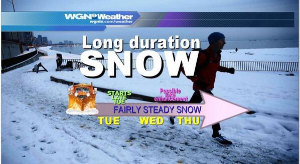
Posted by: Southsider2k12 Dec 30 2013, 08:05 PM
Tom Skilling predicting 9.4 inches in City between tonight and Thursday afternoon.
Posted by: Southsider2k12 Dec 31 2013, 10:23 AM
The National Weather Service snow forecast maps have Michigan City in the band of 6 to 9 inches of snow starting tonight and ending Thursday night. The bands are pretty narrow, and the 5 to 7 inch band starts in the south half of LP County. The situation still sounds pretty fluid though, both based on projected path AND projected speed of the system. The highest totals would be seen on a more southerly and slower track. The lowest totals on a northerly and faster track. Stay tuned.
Posted by: Southsider2k12 Dec 31 2013, 11:19 AM
The latest from Tom Skilling's weather blog.
"Snowfall estimates reach 1-3″ by midnight New Year’s Eve (Tuesday night); 3 to 5” by Wednesday morning and could top 10” by Thursday afternoon in a few harder hit lakeside counties"
http://blog.chicagoweathercenter.com/2013/12/31/long-duration-snow-event-gets-underway-by-new-years-eve-snowfall-to-arrive-in-waves-into-thursday/
Posted by: diggler Dec 31 2013, 03:28 PM
Its friggin TREACHEROUS out there ! 
Posted by: diggler Jan 2 2014, 06:29 AM
LaPorte
Winter Weather Advisory:
Issued at: 3:38 am CST on January 2, 2014/, expires at: 3:00 PM CST on January 02, 2014
...Winter Weather Advisory remains in effect until 4 PM EST /3 PM CST/ this afternoon... Hazardous weather...
timing...light to moderate snow will diminish through the day...ending across Northwest Ohio late this afternoon.
Additional snow accumulations of 1 to 3 inches are possible today.
Northeast winds of 10 to 20 mph with gusts to 25 mph will cause blowing and drifting snow. The strongest wind gusts are expected this afternoon. Impacts...
roads will be snow covered...slick...and hazardous. Visibilities will also be limited at times this morning. This will make travel across the area difficult. Precautionary/preparedness actions... A Winter Weather Advisory for snow means that periods of snow will cause primarily travel difficulties. Be prepared for snow covered roads and limited visibilities...and use caution while driving.
Posted by: Southsider2k12 Jan 2 2014, 08:40 AM
Did you see the temps forecast for next week? YIKES!
Posted by: diggler Jan 2 2014, 08:47 AM
Hopefully it will only last two days. Gonna insulate the pipes later on today.
Posted by: Southsider2k12 Jan 2 2014, 08:47 AM
Lighthouse place isn't opening until noon today.
Posted by: diggler Jan 2 2014, 09:36 AM
Well it could be alot worse. I actually visited this city once....in the summer of course:
http://bit.ly/1cKa5Ih
_
Posted by: diggler Jan 2 2014, 07:57 PM

Posted by: diggler Jan 4 2014, 02:43 AM

Winter Storm Watch
Expiring: 2014-01-06 06:00:00
Areas affected: Iroquois, IL; Jasper, IN; Kankakee, IL; Kankakee, IL; Kenosha, WI; La Porte, IN; Lake, IN; Newton, IN; Porter, IN; Racine, WI; Walworth, WI; Will, IL;
URGENT - WINTER WEATHER MESSAGE NATIONAL WEATHER SERVICE CHICAGO IL 923 PM CST FRI JAN 3 2014 ILZ023-032-033-039-INZ001-002-010-011-019-041130- /O.CON.KLOT.WS.A.0001.140105T0000Z-140106T0600Z/ KANKAKEE-LIVINGSTON-IROQUOIS-FORD-LAKE IN-PORTER-NEWTON-JASPER- BENTON- INCLUDING THE CITIES OF...KANKAKEE...PONTIAC...WATSEKA...PAXTON... GARY...VALPARAISO...MOROCCO...RENSSELAER...FOWLER 923 PM CST FRI JAN 3 2014 /1023 PM EST FRI JAN 3 2014/ ...WINTER WEATHER ADVISORY REMAINS IN EFFECT UNTIL 9 AM CST /10 AM EST/ SATURDAY... ...WINTER STORM WATCH REMAINS IN EFFECT FROM SATURDAY EVENING THROUGH SUNDAY EVENING... FOR THE WINTER WEATHER ADVISORY... * TIMING...CONSIDERABLE BLOWING AND DRIFTING SNOW WITH NEAR BLIZZARD CONDITIONS AT TIMES THROUGH SATURDAY MORNING. * IMPACTS...SOUTHERLY WINDS 20 TO 25 MPH...WITH GUSTS NEAR 35 MPH. THIS WILL CREATE CONSIDERABLE BLOWING AND DRIFTING OF SNOW WITH VISIBILITIES REDUCED TO NEAR ZERO AT TIMES...MAINLY IN OPEN AND RURAL AREAS AND ON EAST WEST ROADS. FOR THE WINTER STORM WATCH... * TIMING...SNOW IS EXPECTED TO DEVELOP ACROSS THE AREA AS EARLY AS SATURDAY AFTERNOON. HOWEVER...SNOW INTENSITIES APPEAR TO INCREASE ACROSS THE AREA SATURDAY NIGHT INTO SUNDAY. THE SNOW SHOULD ABATE BY SUNDAY EVENING. * MAIN IMPACT...THE POTENTIAL FOR PERIODS OF HEAVY SNOW SATURDAY NIGHT INTO SUNDAY COULD RESULT IN 6 OR MORE INCHES OF NEW SNOW ACCUMULATION. THIS COULD MAKE TRAVEL VERY HAZARDOUS ACROSS THE AREA. * OTHER IMPACTS...PERIODS OF HEAVY SNOW...ALONG WITH SOME STIFF NORTHWEST WINDS OF 15 TO 30 MPH COULD RESULT IN CONSIDERABLE BLOWING AND DRIFTING SNOW WITH NEAR BLIZZARD CONDITIONS. PRECAUTIONARY/PREPAREDNESS ACTIONS... A WINTER WEATHER ADVISORY FOR BLOWING SNOW MEANS THAT VISIBILITIES WILL BE LIMITED DUE TO STRONG WINDS BLOWING SNOW AROUND. USE CAUTION WHEN TRAVELING...ESPECIALLY IN OPEN AREAS. A WINTER STORM WATCH MEANS THERE IS A POTENTIAL FOR SIGNIFICANT SNOW ACCUMULATIONS THAT MAY IMPACT TRAVEL. CONTINUE TO MONITOR THE LATEST FORECASTS.
Posted by: diggler Jan 5 2014, 07:44 AM

Winter Storm Warning
Expiring: 2014-01-06 00:00:00
Areas affected: Cook, IL; Cook, IL; DeKalb, IL; DeKalb, IL; DuPage, IL; DuPage, IL; Grundy, IL; Grundy, IL; Iroquois, IL; Iroquois, IL; Jasper, IN; Jasper, IN; Kane, IL; Kane, IL; Kankakee, IL; Kankakee, IL; Kendall, IL; Kendall, IL; Kenosha, WI; La Porte, IN; La Salle, IL; La Salle, IL; Lake, IL; Lake, IL; Lake, IN; Lake, IN; Lee, IL; Lee, IL; McHenry, IL; Newton, IN; Newton, IN; Ogle, IL; Porter, IN; Porter, IN; Racine, WI; Walworth, WI; Will, IL; Will, IL;
URGENT - WINTER WEATHER MESSAGE NATIONAL WEATHER SERVICE CHICAGO IL 400 AM CST SUN JAN 5 2014 ILZ006-010>014-019>022-051800- /O.CON.KLOT.WC.W.0001.140106T0000Z-140107T1800Z/ LAKE IL-LEE-DE KALB-KANE-DUPAGE-COOK-LA SALLE-KENDALL-GRUNDY-WILL- INCLUDING THE CITIES OF...WAUKEGAN...DIXON...DEKALB...AURORA... WHEATON...CHICAGO...OTTAWA...OSWEGO...MORRIS...JOLIET 400 AM CST SUN JAN 5 2014 ...WINTER STORM WARNING REMAINS IN EFFECT UNTIL 6 PM CST THIS EVENING... ...WIND CHILL WARNING REMAINS IN EFFECT FROM 6 PM THIS EVENING TO NOON CST TUESDAY... * TIMING...SNOW IS EXPECTED TO CONTINUE...HEAVY AT TIMES...TODAY INTO THE EARLY EVENING. * MAIN IMPACT...PERIODS OF HEAVY SNOW TODAY WILL RESULT IN 3 TO 5 INCHES OF NEW SNOW ACCUMULATION...LEADING TO HAZARDOUS TRAVEL CONDITIONS. * OTHER IMPACTS...BRISK NORTH TO NORTHWEST WINDS OF 20 TO 30 MPH WILL RESULT IN CONSIDERABLE BLOWING AND DRIFTING SNOW WITH REDUCED VISIBILITY SUNDAY AFTERNOON AND NIGHT. FOR THE WIND CHILL WARNING... * TIMING...A PROLONGED PERIOD OF DANGEROUSLY COLD WIND CHILLS IS EXPECTED TONIGHT THROUGH TUESDAY MORNING. WHILE DANGEROUS WIND CHILLS ARE LIKELY THROUGH THE PERIOD...THE MOST EXTREME WIND CHILLS ARE LIKELY TO BE LATE TONIGHT AND MONDAY NIGHT. * WIND CHILLS...A PROLONGED PERIOD OF WIND CHILLS LOWER THAN 30 BELOW IS EXPECTED...WITH WIND CHILLS OF 40 TO 50 BELOW EXPECTED LATE TONIGHT INTO MONDAY AFTERNOON AND AGAIN EARLY TUESDAY MORNING. PRECAUTIONARY/PREPAREDNESS ACTIONS... A WINTER STORM WARNING MEANS SIGNIFICANT AMOUNTS OF SNOW ARE EXPECTED OR OCCURRING. STRONG WINDS ARE ALSO POSSIBLE. THIS WILL MAKE TRAVEL VERY HAZARDOUS OR IMPOSSIBLE. A WIND CHILL WARNING MEANS THE WIND WILL COMBINE WITH VERY COLD AIR TO CREATE DANGEROUSLY LOW WIND CHILL VALUES. THIS WILL RESULT IN FROST BITE AND LEAD TO HYPOTHERMIA OR DEATH IF PRECAUTIONS ARE NOT TAKEN. BRING PETS INDOORS.
Posted by: diggler Jan 5 2014, 12:11 PM
Anybody look out the window yet today ?? Hope I'll be able to find the car next morning.
Posted by: Southsider2k12 Jan 5 2014, 07:38 PM
LaPorte County is now officially in a Blizzard Warning until 6 am tomorrow morning.
Posted by: Dave Jan 5 2014, 08:59 PM
South Shore / NICTD is not running Monday.
Usual city garbage pick up for Monday has been set back a day.
And after this blizzard, we're going to have a couple of days where the temperature will not be getting over 0 °F. Such fun!
Posted by: Southsider2k12 Jan 5 2014, 09:17 PM
At this point, most everything is closed for Monday. No meetings, no recycling, no courts, no government, Malls are both closed. Interstates are closed, and the plows have been pulled off the county and state streets.
Posted by: Dave Jan 6 2014, 02:34 AM
Holy crap! There's a four foot drift between my house and my garage -- and they're only about eight feet apart!
Snowblower's going to get a workout tomorrow -- if I can get into the garage at all.
Posted by: diggler Jan 6 2014, 06:56 AM

Seems like the entire Midwest is at a standstill today. Really insanely cold out there this morning.
http://bit.ly/1bKdqCM
Posted by: Southsider2k12 Jan 6 2014, 10:18 AM
Looking out my backdoor.
Posted by: diggler Jan 6 2014, 12:46 PM
NASTY DRIFTS
Posted by: diggler Jan 17 2014, 08:38 AM

Hope it don't last long. I wanna hit the Calumet Trail soon again.
Posted by: Southsider2k12 Jan 19 2014, 04:45 PM
The National Weather Service has placed the Region under a Lake Effect Snow watch, with the warning that one to two FEET of snow are possible. The watch is set to start at 6pm tomorrow night. If you end up in a snow band one to three inches per HOUR is possible. The band are predicted to set up Monday night and last into Tuesday afternoon.
Posted by: Southsider2k12 Jan 19 2014, 04:46 PM
This is a CBTL.org level four Lake Effect Snow warning. This is not a test. Please proceed to your nearest grocery store and grab all of the three B's. Bread, Batteries, and Booze. Repeat this is not a test.
Posted by: diggler Jan 19 2014, 05:43 PM
Lets just hope we don't get that predicted freezing drizzle tomorrow morning, before the Snowmageddon, Snowpocalypse, Snowzilla or whatever else the hell you call it hits.
Posted by: Southsider2k12 Jan 19 2014, 09:08 PM
Galloping around the weather pages, there is about a 20 mile variation showing up so far in where the heaviest bands will set up starting tomorrow night into Tuesday. One I saw has the worst centering at about the Lake/Porter County line. Another has the bullseye bisecting Porter County. WSBT's Matt Ruskin and the National Weather Service have the bullseye over the Porter/LaPorte County line and Michigan City respectively. It looks like at the very least we will see something like 6 inches of snow if the set up is to our west. If the set up is along the Porter/LaPorte line, the totals could vary with exactly what street you live on, and could go something like two feet in the County Line Road/Pines area, while out toward LaLumiere sees something like six inches. We are about 24 hours away from the first flakes, so we will see how the wind forecasts look as we go through tomorrow to get a more accurate feel for an exact cone of death by snow.
Posted by: diggler Jan 20 2014, 06:35 AM

I'm getting cabin fever already.
_
Posted by: Southsider2k12 Jan 20 2014, 10:19 AM
The early morning forecasting has pushed all of the snow models that I have seen for tonight into Tuesday, further West than was being talked about last night. Now it looks like City will avoid much of the snow. Lake and even Cook Counties have been added to the watches, while expectation for our area seen to have fallen into the 1 to 3" range. Wind direction expectations have moved from NNW/N to NNE, which aims the system more towards the Gary/Merrillville sector. Again stay tuned.
Posted by: diggler Jan 21 2014, 06:28 AM

Lake Effect snow plume working its way back east
Posted on Jan 21 2014 - 4:17 am by pdaileywgntv
As winds slowly shift from the north to the northwest this morning the plume of heavy lake-effect snow will slowly work its way east into northwest Indiana (monitor current radar mosaic at top of this page). After reaching as far inland as Interstate-355, as of 4AM the lake-effect plume had moved back to the east of O’Hare Airport. Heavy snow was letting up a bit at Midway Airport where 6.1 inches of new snow had been recorded (3 inches since midnight) with light snow reported in Lansing.
Posted by: Southsider2k12 Jan 21 2014, 11:08 AM
The last hour and a half has actually seen the lake effect plume move backwards towards the Illinois state line, instead of to the East and towards us. The longer it takes the system to actually move this way, the better chance it is that the plume is DOA by the time it would get here. Weather Channel still is calling for 4-6 inches in City, but I just don't buy it.
Posted by: diggler Jan 21 2014, 01:28 PM
Lake effect clouds moving in from the west now.
Posted by: Southsider2k12 Jan 21 2014, 01:54 PM
Lake effect clouds moving in from the west now.
It is really drying up now.
Posted by: Southsider2k12 Jan 22 2014, 11:07 AM
All roads to Chicago are still snow-covered and slick.
http://www.nwitimes.com/news/local/lake/borman-still-snow-covered-slick-following-lake-effect-blast/article_0f90b5bf-4010-5e57-9be4-1ee6da8edc71.html
Posted by: diggler Jan 22 2014, 11:13 AM
Hope we get an early spring....like about the 1st week of February.
_
Posted by: diggler Jan 23 2014, 02:20 PM
Snowing like the friggin dickens here now.
Posted by: diggler Jan 25 2014, 03:51 PM
Alerts for La Porte County
WINTER WEATHER ADVISORY NOW IN EFFECT
UNTIL 7 AM EST /6 AM CST/ MONDAY
Wswiwx
Urgent - Winter Weather Message
National Weather Service Northern Indiana
316 PM EST Sat Jan 25 2014
.Northwest Winds Behind A Cold Front Will Usher IN Much Colder Air
Tonight. This Will Cause Lake Effect Snow Showers To Continue Over
Southern Michigan And The Adjacent Counties IN Northern Indiana
Through This Evening. Gusty Northwest Winds Will Result In
Continued Blowing And Drifting Snow Through This Evening Before
Wind Speeds Taper. Temperatures Will Also Be Falling Behind The
Front Tonight Leading To Wind Chills As Cold As 15 Below Zero.
Another Fast Moving System Will Allow Snow To Overspread The Area
From West To East Late Tonight Into Sunday Morning, Before
Beginning To Taper Sunday Afternoon. This System Is Expected To Bring
An Additional 2 To 4 Inches Of Snow. Winds Will Strengthen Again
Sunday Afternoon And Sunday Evening As Another Arctic Front
Approaches Resulting IN More Blowing And Drifting Snow. Dangerous
Wind Chills Of 20 Below To 35 Below Are Expected Behind This Front
Monday Through Wednesday.
La Porte-St. Joseph IN-Elkhart-Lagrange-Steuben-Noble-De Kalb-
Starke-Pulaski-Marshall-Fulton IN-Kosciusko-Whitley-Allen IN-
White-Cass IN-Miami-Wabash-Huntington-Wells-Adams-Grant-Blackford-
Jay-Berrien-Cass MI-St. Joseph MI-Branch-Hillsdale-Williams-
Fulton OH-Defiance-Henry-Paulding-Putnam-Van Wert-Allen OH-
Including The Cities Of, Michigan City, La Porte, South Bend,
Mishawaka, New Carlisle, Walkerton, Elkhart, Goshen,
Nappanee, Lagrange, Topeka, Shipshewana, Angola, Fremont,
Kendallville, Ligonier, Albion, Auburn, Garrett, Knox,
North Judson, Bass Lake, Winamac, Francesville, Medaryville,
Plymouth, Bremen, Culver, Rochester, Akron, Warsaw,
Winona Lake, Syracuse, Mentone, Columbia City, Tri-Lakes,
South Whitley, Fort Wayne, New Haven, Monticello, Brookston,
Monon, Logansport, Royal Center, Peru, Grissom Afb, Mexico,
Wabash, North Manchester, Huntington, Roanoke, Bluffton,
Ossian, Decatur, Berne, Marion, Gas City, Upland,
Hartford City, Montpelier, Portland, Dunkirk, Niles,
Benton Harbor, St. Joseph, Buchanan, Dowagiac, Cassopolis,
Marcellus, Sturgis, Three Rivers, White Pigeon, Mendon,
Coldwater, Bronson, Hillsdale, Litchfield, Jonesville,
Bryan, Wauseon, Archbold, Fayette, Swanton, Defiance,
Sherwood, Hicksville, Napoleon, Deshler, Liberty Center,
Paulding, Antwerp, Melrose, Ottawa, Pandora, Kalida,
Fort Jennings, Van Wert, Delphos, Ohio City, Lima,
Spencerville
316 PM EST Sat Jan 25 2014 /216 PM Cst Sat Jan 25 2014/
, Winter Weather Advisory Now IN Effect Until 7 AM EST /6 Am
Cst/ Monday,
, Wind Chill Watch IN Effect From Monday Morning Through
Wednesday Afternoon,
The National Weather Service IN Northern Indiana Has Issued A
Wind Chill Watch, Which Is IN Effect From Monday Morning Through
Wednesday Afternoon. The Winter Weather Advisory Is Now IN Effect
Until 7 AM EST /6 AM Cst/ Monday.
Hazardous Weather,
* Additional Snow Accumulations Through This Evening Of Up To An
Inch Across Northeast Indiana And Northwest Ohio, With 1 To 2
Inches Across Southwest Lower Michigan Where Lake Effect Snow
Showers May Persist Through Late Evening. Snow Will Increase
From West To East Late Tonight Into Sunday Morning Before
Tapering Sunday Afternoon. An Additional 2 To 4 Inches Of Snow
Accumulation Is Expected.
* Blowing And Drifting Snow Will Continue Through Early This
Evening, Causing Some Unplowed Roads To Be Impassable. Blowing
And Drifting Snow Will Become More Widespread Late Sunday
Afternoon Into Sunday Night As Winds Strengthen Once Again.
* Wind Chills To 15 Below Zero Tonight And Sunday
Night, Dropping To 20 Below Zero To 35 Below Zero For Much Of
The Monday Through Wednesday Morning Period.
Impacts,
* Travel Will Be Hazardous Tonight Through Sunday Night Due To
Snow, And Blowing And Drifting Snow.
* Dangerous Wind Chills For Much Of The Monday Through Wednesday
Period Can Lead To Frostbite Of Exposed Skin IN A Matter Of
Minutes.
Precautionary/Preparedness Actions,
A Winter Weather Advisory For Snow Means That Periods Of Snow
Will Cause Primarily Travel Difficulties. Be Prepared For Snow
Covered Roads And Limited Visibilities, And Use Caution While
Driving.
A Winter Weather Advisory For Blowing Snow Means That
Visibilities Will Be Limited Due To Strong Winds Blowing Snow
Around. Use Caution When Traveling. Some Roads IN Open Areas May
Be Impassable.
A Wind Chill Watch Means There Is The Potential For A Combination
Of Very Cold Air And Strong Winds To Create Dangerously Low Wind
Chill Values. Monitor The Latest Forecasts And Warnings For
Updates On This Situation.
&&
Issue Time:1/25/2014 2:16:00 PM
Valid Until:1/25/2014 10:30:00 PM
Posted by: Southsider2k12 Jan 25 2014, 05:58 PM
:crying
Posted by: diggler Jan 25 2014, 07:01 PM
Another repeat of this kind of winter weather, and it will be time to start packing.
Posted by: Southsider2k12 Jan 30 2014, 03:00 PM
So it looks like an inch of snow about to start here today, six more inches on Saturday, and then maybe another big hit on Tuesday into Wed.
This is the winter that never ends...
Posted by: diggler Jan 30 2014, 05:06 PM
A WINTER STORM WATCH IS IN EFFECT UNTIL 10:00PM EST SATURDAY, FEBRUARY 01
Issue Time: 2:56PM CST, Thursday Jan 30, 2014
Valid Until: 11:00PM CST, Thursday Jan 30, 2014
WINTER STORM WATCH IN EFFECT FROM LATE FRIDAY NIGHT
THROUGH SATURDAY EVENING
Wswiwx
Urgent - Winter Weather Message
National Weather Service Northern Indiana
356 PM EST Thu Jan 30 2014
... Winter Storm Taking Shape For Saturday...
.Low Pressure Is Expected To Develop Over The Southern Plains
Friday Night And Then Lift Northeast Into The Eastern Great Lakes
By Saturday Evening. Accumulating Snow Is Expected To Develop Late
Friday Evening And Increase IN Intensity Saturday Morning. A
Period Of Heavy Snow Is Possible From Mid Morning Through Early
Afternoon Saturday Before Diminishing IN Intensity During The
Evening. Some Sleet May Mix IN With The Snow South Of The Highway
20 Corridor IN Indiana Midday Saturday.
Storm Total Snowfall Accumulations Of 6 Inches Or More Is Expected.
La Porte-St. Joseph IN-Elkhart-Berrien-Cass MI-St. Joseph MI-
Including The Cities Of... Michigan City... La Porte... South Bend...
Mishawaka... New Carlisle... Walkerton... Elkhart... Goshen...
Nappanee... Niles... Benton Harbor... St. Joseph... Buchanan...
Dowagiac... Cassopolis... Marcellus... Sturgis... Three Rivers...
White Pigeon... Mendon
356 PM EST Thu Jan 30 2014 /256 PM Cst Thu Jan 30 2014/
... Winter Storm Watch IN Effect From Late Friday Night Through
Saturday Evening...
The National Weather Service IN Northern Indiana Has Issued A
Winter Storm Watch... Which Is IN Effect From Late Friday Night
Through Saturday Evening.
Hazardous Weather...
* Light Snow Will Develop Late Friday Evening And Become Heavier
By Daybreak Saturday. A Period Of Heavy Snow Is Possible From
Mid Morning Through Early Afternoon Saturday. Sleet May Mix In
With The Snow For A Time Midday Saturday South Of The Highway
20 Corridor IN Indiana.
* Storm Total Snow Accumulations Of 6 Inches Or More Is Expected.
* Snow Fall Rates Of 1 Inch Per Hour Are Possible At Times.
Impacts...
* Snow Covered Roads And Low Visibilities May Produce Hazardous
Travel Conditions Early Saturday Morning Into Saturday Evening.
Precautionary/Preparedness Actions...
A Winter Storm Watch Means There Is A Potential For Significant
Snow... Sleet... Or Ice Accumulations That May Impact Travel.
Continue To Monitor The Latest Forecasts.
Posted by: diggler Jan 31 2014, 09:29 AM

Posted by: diggler Feb 1 2014, 08:00 AM

LET'S ALL HOPE SO
http://bit.ly/1dUx5R7
_
Posted by: diggler Feb 3 2014, 03:31 AM
WINTER STORM WATCH IN EFFECT FROM TUESDAY AFTERNOON
THROUGH WEDNESDAY AFTERNOON
Urgent - Winter Weather Message
National Weather Service Northern Indiana
425 AM EST Mon Feb 3 2014
, Winter Storm Developing,
.A Strong Storm System Will Move Quickly From The Southeast Texas
Coast Early Tuesday And Intensify As It Lifts Northeast Through
The Tennessee Valley And Then To Southwest Pennsylvania By Daybreak
Wednesday. Snow Will Quickly Overspread The Region Tuesday
Afternoon From The Southwest To The Northeast And Become Heavy At
Times Tuesday Night. Snowfall Rates Of 1 To 2 Inches Per Hour Are
Possible With Greatly Reduced Visibilities. Total Snowfall
Amounts By Midday Wednesday Is Anticipated To Be Generally IN The
6 To 10 Inch Range. IN Addition, North Winds Will Increase And
Likely Cause Significant Areas Of Blowing Snow To Develop Wednesday
Morning, Especially IN Open And Rural Areas, Primarily Affecting
East To West Roadways.
The Winter Storm Watch Is Based On The Latest Information And Is
Subject To Change, Depending On The Storms Exact Track And
Strength. Listen For Later Updates On This Developing Winter
Storm.
La Porte-St. Joseph IN-Elkhart-Lagrange-Steuben-Noble-De Kalb-
Starke-Pulaski-Marshall-Fulton IN-Kosciusko-Whitley-Allen IN-
White-Cass IN-Miami-Wabash-Huntington-Wells-Adams-Grant-Blackford-
Jay-Berrien-Cass MI-St. Joseph MI-Branch-Hillsdale-Williams-
Fulton OH-Defiance-Henry-Paulding-Putnam-Van Wert-Allen OH-
Including The Cities Of, Michigan City, La Porte, South Bend,
Mishawaka, New Carlisle, Walkerton, Elkhart, Goshen,
Nappanee, Lagrange, Topeka, Shipshewana, Angola, Fremont,
Kendallville, Ligonier, Albion, Auburn, Garrett, Knox,
North Judson, Bass Lake, Winamac, Francesville, Medaryville,
Plymouth, Bremen, Culver, Rochester, Akron, Warsaw,
Winona Lake, Syracuse, Mentone, Columbia City, Tri-Lakes,
South Whitley, Fort Wayne, New Haven, Monticello, Brookston,
Monon, Logansport, Royal Center, Peru, Grissom Afb, Mexico,
Wabash, North Manchester, Huntington, Roanoke, Bluffton,
Ossian, Decatur, Berne, Marion, Gas City, Upland,
Hartford City, Montpelier, Portland, Dunkirk, Niles,
Benton Harbor, St. Joseph, Buchanan, Dowagiac, Cassopolis,
Marcellus, Sturgis, Three Rivers, White Pigeon, Mendon,
Coldwater, Bronson, Hillsdale, Litchfield, Jonesville,
Bryan, Wauseon, Archbold, Fayette, Swanton, Defiance,
Sherwood, Hicksville, Napoleon, Deshler, Liberty Center,
Paulding, Antwerp, Melrose, Ottawa, Pandora, Kalida,
Fort Jennings, Van Wert, Delphos, Ohio City, Lima,
Spencerville
425 AM EST Mon Feb 3 2014 /325 AM Cst Mon Feb 3 2014/
, Winter Storm Watch IN Effect From Tuesday Afternoon Through
Wednesday Afternoon,
The National Weather Service IN Northern Indiana Has Issued A
Winter Storm Watch, Which Is IN Effect From Tuesday Afternoon
Through Wednesday Afternoon.
Hazardous Weather,
* Snow Overspreads Tuesday Afternoon And Evening
* Snow Heavy At Times Tuesday Night
* Total Accumulations Of 6 To 10 Inches Possible
* Areas Of Blowing And Drifting Snow Develops Wednesday
Impacts,
* Snow Covered Roads And Reduced Visibilities IN Heavier Snow
Bursts Will Produce Extremely Hazardous Travel Conditions
By Tuesday Night.
* Difficult Morning Commute Wednesday Morning
* Increasing North Wind Wednesday Morning To Cause
Drifting, Primarily On East To West Roads
Precautionary/Preparedness Actions,
A Winter Storm Watch Means There Is A Potential For Significant
Snow, Sleet, Or Ice Accumulations That May Impact Travel.
Continue To Monitor The Latest Forecasts.
&&
Issue Time:2/3/2014 3:25:00 AM
Valid Until:2/3/2014 11:30:00 AM
Posted by: Southsider2k12 Feb 3 2014, 09:01 AM
Tuesday sounds like 6 more inches. Saturday also coming together for another shot of decent snow totals.
Posted by: JHeath Feb 3 2014, 12:03 PM
Tuesday sounds like 6 more inches. Saturday also coming together for another shot of decent snow totals.

Posted by: Southsider2k12 Feb 3 2014, 01:36 PM
The answer is no. IT WILL NEVER END

Posted by: diggler Feb 3 2014, 03:54 PM
Anybody been out to the Dunes lately ?
Posted by: Job Feb 5 2014, 07:59 AM
Anybody been out to the Dunes lately ?
Does anyone know the total snow accumulation for January?
Posted by: Southsider2k12 Feb 5 2014, 09:12 AM
Does anyone know the total snow accumulation for January?
Is a metric F@#$ ton close enough?
Posted by: Ang Feb 5 2014, 12:11 PM
Is a metric F@#$ ton close enough?
I was going to say, "Too durn much" but I like your answer better.

Posted by: Tim Feb 5 2014, 03:10 PM
Is a metric F@#$ ton close enough?
Stop - you had me at F@#$.
lol
Posted by: diggler Feb 5 2014, 05:14 PM
Whiteout conditions now this evening.
Posted by: diggler Feb 17 2014, 06:43 AM
WINTER WEATHER ADVISORY NOW IN EFFECT FROM NOON EST /11 AM CST/ TODAY TO 11 PM EST /10 PM CST/ THIS EVENING
UNTIL 12:45PM EST
Urgent - Winter Weather Message, Corrected
National Weather Service Northern Indiana
416 AM EST Mon Feb 17 2014
La Porte-St. Joseph IN-Elkhart-Starke-Pulaski-Marshall-Fulton IN-
Kosciusko-Berrien-Cass MI-
Including The Cities Of, Michigan City, La Porte, South Bend,
Mishawaka, New Carlisle, Walkerton, Elkhart, Goshen,
Nappanee, Knox, North Judson, Bass Lake, Winamac,
Francesville, Medaryville, Plymouth, Bremen, Culver,
Rochester, Akron, Warsaw, Winona Lake, Syracuse, Mentone,
Niles, Benton Harbor, St. Joseph, Buchanan, Dowagiac,
Cassopolis, Marcellus
416 AM EST Mon Feb 17 2014 /316 AM Cst Mon Feb 17 2014/
, Winter Weather Advisory Now IN Effect From Noon EST /11 Am
Cst/ Today To 11 PM EST /10 PM Cst/ This Evening,
The Winter Weather Advisory Is Now IN Effect From Noon EST /11 Am
Cst/ Today To 11 PM EST /10 PM Cst/ This Evening.
Hazardous Weather,
* A Band Of Moderate To Heavy Snow Will Overspread The Area This
Afternoon And Evening. Visibilities May Be Reduced To Less
Than A Quarter Of A Mile At Times.
* Wind Gusts Of 20 To 30 Mph Will Likely Create Areas Of Blowing
And Drifting Snow.
* Snow Accumulations 4 To 6 Inches.
Impacts,
* Roads Will Become Snow Covered And Slippery This Afternoon And
Evening.
Precautionary/Preparedness Actions,
A Winter Weather Advisory For Snow Means That Periods Of Snow
Will Cause Primarily Travel Difficulties. Be Prepared For Snow
Covered Roads And Limited Visibilities, And Use Caution While
Driving.
&&
Issue Time:2/17/2014 3:16:00 AM
Valid Until:2/17/2014 11:45:00 AM
Posted by: diggler Feb 20 2014, 05:11 PM
Fogmageddon time in LP county this evening. Sirens blasting nonstop on 421. CAN'T SEE NOTHING
Posted by: Groucho Feb 20 2014, 05:43 PM
Fogmageddon time in LP county this evening. Sirens blasting nonstop on 421. CAN'T SEE NOTHING
You guys are about to be hit with a line of thunderstorms. That may clear out the Fog. It's a fast moving line and its passing Gary right now. I might make it worse....Who knows.
Posted by: Ang Feb 24 2014, 04:09 PM
Fogmageddon time in LP county this evening. Sirens blasting nonstop on 421. CAN'T SEE NOTHING

I love that description. It was a Fogmageddon that day too!
Posted by: taxthedeer Feb 25 2014, 06:58 AM

Posted by: Southsider2k12 Feb 27 2014, 01:18 PM
Matt Ruskins early run is calling for 4-7", mostly Sunday into Sunday night.
Posted by: diggler Feb 27 2014, 01:54 PM
Maybe I can make some snowballs:
http://www.youtube.com/watch?v=FATHNEzH1lk
_
Posted by: Southsider2k12 Feb 28 2014, 02:57 PM
Matt Ruskins early run is calling for 4-7", mostly Sunday into Sunday night.
Most of the models seem to be hitting this range.
Posted by: Southsider2k12 Mar 2 2014, 12:18 PM
Portage, IN - Local Weather Service
Because of the ice on the lake, there is what is called a low-level inversion. This is keeping the radar from picking up a lot of what may or may not be developing, which is why the forecast is so messed up. Latest meso trends support addition lake snows through the afternoon, but model guidance isn't picking up on it well. But since models are based on future simulation of radar trend we may still get it. Or we may not. Best advice is to be prepared for a possible renewed bout of lake snow.
Posted by: Groucho Mar 5 2014, 02:09 PM
When will this $*am snow end....???
https://encrypted-tbn0.gstatic.com/images?q=tbn:ANd9GcQSOGfUxaEs3zo4jR8FBBpfEAaJCcaUBA_afSFvSED_hBJrdhnzbw
Posted by: diggler Mar 5 2014, 04:47 PM
Anybody hear any sirens yesterday ??
Indiana residents receive old tornado alerts
LAFAYETTE, Ind. (AP) — The National Weather Service is investigating why some northwestern Indiana residents received alerts Tuesday about a tornado warning even though the day was sunny and cold with no severe weather in sight.
Residents received alerts on their phones, saw warnings on their televisions or heard radio warnings of a tornado. They even went to Tippecanoe County Sheriff Tracy Brown, who got the alerts on his cellphone.
"I received two alerts. One said there was a tornado warning until 3 p.m.; the other said 3:15 p.m. and to take shelter now," Brown told the Journal & Courier.
On closer inspection, he discovered those alerts were dated from 107 days ago, or about the time of the Nov. 17 tornado outbreak across Indiana.
The National Weather Service said that stations in Indianapolis, Chicago and Fort Wayne were not responsible for the alerts even though the end of the alert read "-NWS."
Weather Service meteorologist Gino Izzi said a tornado warning test was issued Tuesday for Illinois, but that alert clearly stated that it was a test and did not affect Indiana. He the weather service is investigating Tuesday's tornado warning incident.
"Those higher up are investigating," he added.
Tippecanoe Emergency Management Agency Director Smokey Anderson said he and his team don't know which agency sent the alert, but he heard the warning early on Tuesday.
"We had several calls to our office when it was happening," Anderson said.
However, there was no panic over the alerts, and none of the county's 72 outdoor warning sirens activated, he said.
"It's important enough that we don't want people thinking we don't know what we are doing and telling them to take shelter when it is sunny and 20 degrees," Anderson said.
Posted by: Southsider2k12 Mar 5 2014, 07:39 PM
They set the sirens off in Valpo yesterday.
Posted by: diggler Mar 10 2014, 04:58 PM
Felt like a heatwave out there today.
Posted by: Southsider2k12 Mar 10 2014, 05:15 PM
Felt like a heatwave out there today.
And it is supposed to snow on Wed...
Posted by: Southsider2k12 Mar 11 2014, 11:36 AM
Gathering up the various snow forecasts for the pending snow event looks like this...
All of the forecasters are upping their totals since the last 24 hours. Most were either 2-4 or 3-5 inches as of yesterday. Now most are 4-8 inches, with the emphasis on the heavier side. The big thing is that this going to be warm snow, so instead of the puffier flakes we have seen for lots of storms this winter, it is going to be the thicker/heavier lake effect style flakes. The lucky part for us is that the lake is mostly frozen, because if it weren't we could have been looking at another potential foot of snow from the winds on the back end of this storm. We could have had a 1998 type event on our hands, as winds will be northerly around 30 mph long after the actual snow system moves out of the area.
Tom Skilling has us in a band for 6 to 8 inches, the WGN forcast map has City for 7.1". NBC 5 calling for 4-8, with 10+ inches possible in heavier bands, NWS is saying 4"-8", Matt Ruskin for WSBT is calling for 5-8 inches, The Weather Channel is saying 3-5 inches but has pushed the 5-8 band into southern Porter and LaPorte County over the last day.
Posted by: Ang Mar 11 2014, 11:51 AM
1998-It was about this time of year, too.
That was the year they took all the kids to school, then at 8:30 am called a snow day and the busses turned around and took them all home. That was a major snafu! I kept my son home from school that day and I'm glad I did.
Before it was all said and done, I think we got almost 3 feet!
Posted by: Southsider2k12 Mar 11 2014, 12:02 PM
1998-It was about this time of year, too.
That was the year they took all the kids to school, then at 8:30 am called a snow day and the busses turned around and took them all home. That was a major snafu! I kept my son home from school that day and I'm glad I did.
Before it was all said and done, I think we got almost 3 feet!
It was March 9, 1998.
Posted by: Southsider2k12 Mar 11 2014, 12:16 PM
Lake Michigan sets a new ice coverage record.
http://www.nwitimes.com/news/local/lake/lake-michigan-ice-cover-breaks--year-old-record/article_6bb8b7fb-edc2-5721-b066-f671795e4457.html
Posted by: Michigan City Wolves Mar 18 2014, 03:22 PM
According to Meteorlogist, Mike Hoffman out of south bend, temperatures will remain around normal for the next few days, and then early next week, another blast of cold air is coming with yes a chance of snow that could stick. I like snow but this is getting out of hand. I am not sure when Michigan City will start there baseball season at this point
Posted by: diggler Mar 19 2014, 03:48 AM
The lucky part for us is that the lake is mostly frozen,
Didn't look like it to me yesterday:

Posted by: Southsider2k12 Mar 19 2014, 09:52 AM
Didn't look like it to me yesterday:
A ton of the ice has gone away in the last week.
Posted by: Southsider2k12 Mar 25 2014, 07:13 AM
Roads are horrible this morning. Ice everywhere, sliding through intersections, spinning tires, etc.
Be careful!
Posted by: diggler Mar 25 2014, 07:16 AM
Hope Skilling is right about this weekend forecast. Enough already !
Snow ahd tonite/wintry temps Tue. But yrs warmest air due later this wknd. Historic avg 1st date of 70 is Mar 26. Could happen this Sun/Mon.
Posted by: Southsider2k12 Apr 1 2014, 08:47 AM
US National Weather Service Chicago Illinois
18 secs ·
The December to March period was the coldest on record in Chicago and the second coldest on record in Rockford!
Posted by: diggler Apr 1 2014, 10:39 AM
Mid 80's had to be the coldest on record. Everybody's car on the block had their hoods opened.
Powered by Invision Power Board (http://www.invisionboard.com)
© Invision Power Services (http://www.invisionpower.com)