
  |

 Jan 15 2016, 11:13 AM Jan 15 2016, 11:13 AM
Post
#681
|
|
 Really Comfortable  Group: Members Posts: 1,177 Joined: 19-November 09 Member No.: 969 |
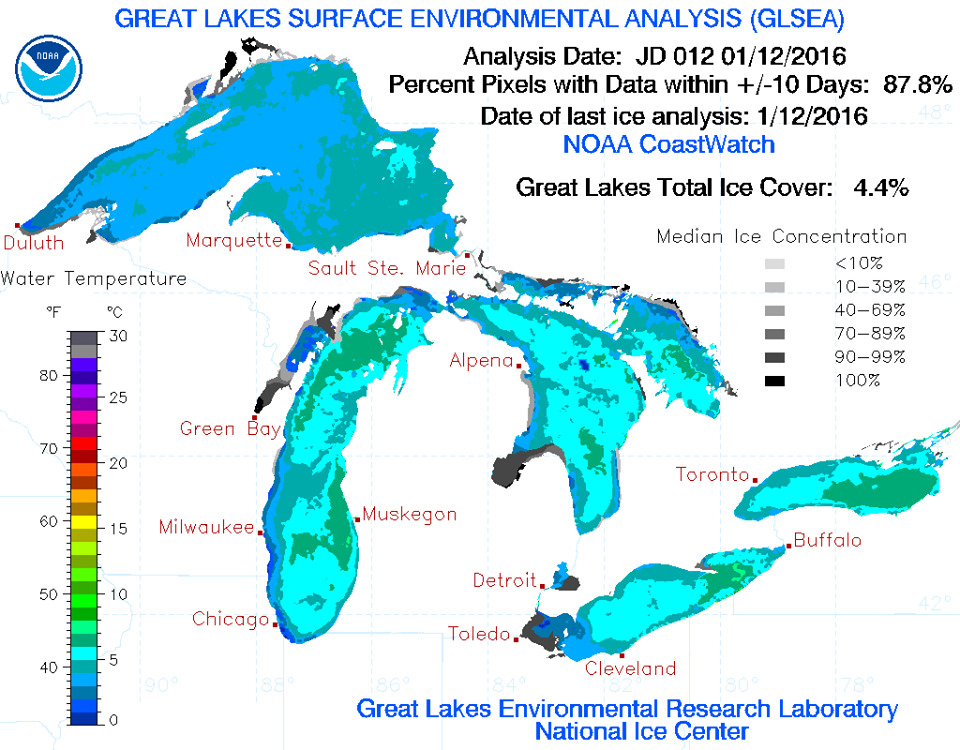 In other words.....MORE LAKE EFFECT SNOW FOR THIS SEASON  _ |
   |

 
|
|
Jan 16 2016, 05:45 AM
Post
#682
|
|
|
Really Comfortable Group: Members Posts: 1,177 Joined: 19-November 09 Member No.: 969 |
  I could live with that.  _ |
|
|
|
|
Jan 16 2016, 09:15 AM
Post
#683
|
|
|
Really Comfortable Group: Members Posts: 1,177 Joined: 19-November 09 Member No.: 969 |
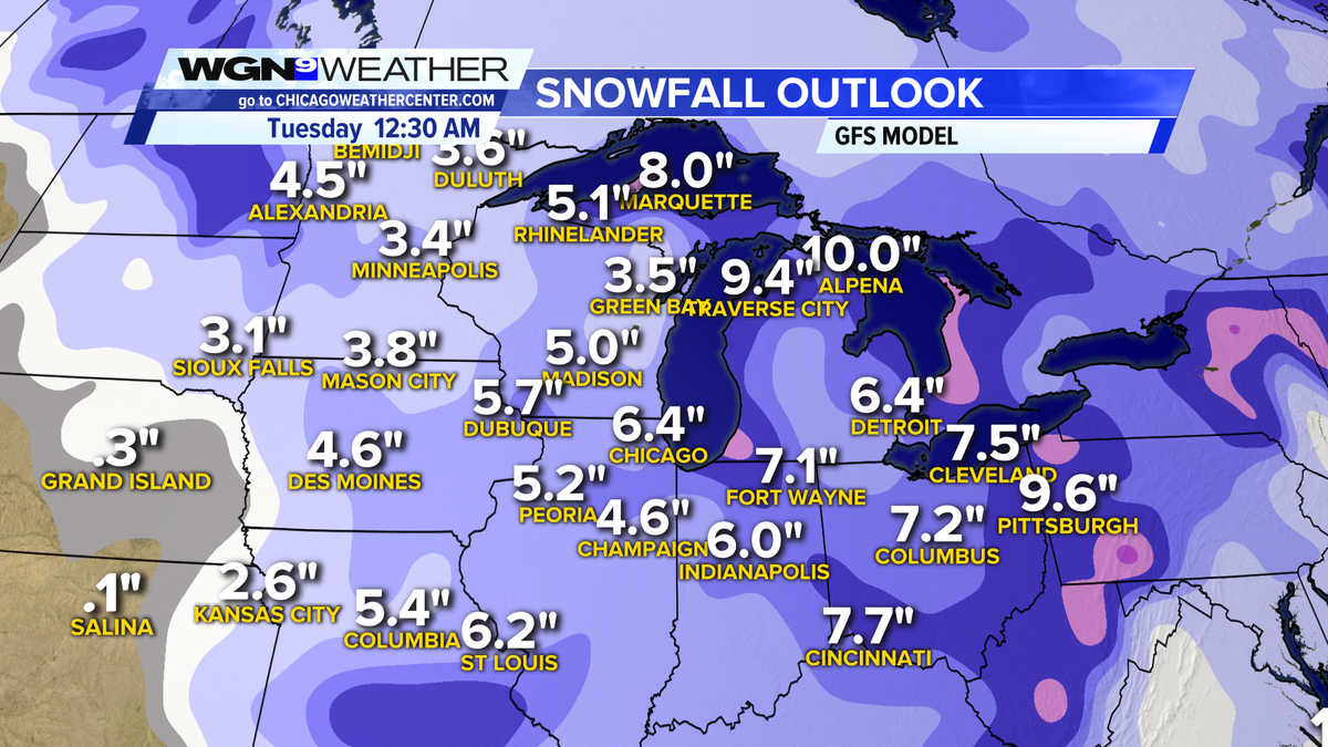
In the meantime......
Special Weather Statement Counties affected: Adams; Allen; Blackford; Cass; De Kalb; Elkhart; Fulton; Grant; Huntington; Jay; Kosciusko; La Porte; Lagrange; Marshall; Miami; Noble; Pulaski; St. Joseph; Starke; Steuben; Wabash; Wells; White; Whitley Expires 9:00 PM on Tuesday, January 19th 2016 Special Weather Statement issued January 16 at 8:04AM EST until January 19 at 9:00PM EST by NWS NorthernIndiana ...ICY PATCHES THIS MORNING... A COMBINATION OF LIGHT SNOWFALL OVERNIGHT AND PATCHY LIGHT DRIZZLE WILL CAUSE ICY PATCHES...ESPECIALLY ON UNTREATED SECONDARY ROADS... BRIDGES AS WELL AS SIDEWALKS AND PARKING LOTS THIS MORNING. USE CAUTION TO AVOID ACCIDENTS...SLIPS AND FALLS. |
|
|
|
|
Feb 9 2016, 07:14 AM
Post
#684
|
|
|
Really Comfortable Group: Members Posts: 1,177 Joined: 19-November 09 Member No.: 969 |
 Thought it would never get here. |
|
|
|
|
Feb 10 2016, 06:53 AM
Post
#685
|
|
|
Really Comfortable Group: Members Posts: 1,177 Joined: 19-November 09 Member No.: 969 |
Winter Weather Advisory Counties affected: Elkhart; La Porte; St. Joseph Expires 10:00 AM on Thursday, February 11th 2016 Winter Weather Advisory issued February 10 at 3:55AM EST until February 11 at 10:00AM EST by NWS NorthernIndiana ...WINTER WEATHER ADVISORY REMAINS IN EFFECT UNTIL 10 AM EST /9 AM CST/ THURSDAY... HAZARDOUS WEATHER... * LAKE EFFECT SNOW SHOWERS WILL PERSIST INTO THURSDAY MORNING. * SNOWFALL RATES OF 1 TO 2 INCHES PER HOUR WILL BE POSSIBLE IN THE STRONGEST SNOWBANDS WITH SUDDEN REDUCTION IN VISIBILITIES TO NEAR ZERO AT TIMES. THE MORNING COMMUTE ON WEDNESDAY MAY BE ADVERSELY AFFECTED BY BANDS OF HEAVIER LAKE EFFECT SNOW SHOWERS AND REDUCED VISIBILITIES. * BLOWING AND MINOR DRIFTING OF SNOW IS EXPECTED TONIGHT AND WEDNESDAY. * WIND CHILL TEMPERATURES WILL RANGE FROM 5 BELOW TO 5 ABOVE ZERO THURSDAY MORNING. * ADDITIONAL ACCUMULATIONS IN THE ADVISORY AREA WILL BE HIGHLY VARIABLE GIVEN THE FREQUENTLY MOVING SNOW BANDS...RANGING FROM LESS THAN AN INCH TO LOCALLY AS HIGH AS 6 INCHES BY LATE THURSDAY MORNING. HIGHEST AMOUNTS WILL BE IN BERRIEN AND CASS COUNTIES IN MICHIGAN... AND NORTHEAST LAPORTE AND NORTHERN SAINT JOSEPH COUNTIES IN INDIANA. IMPACTS... * ROADS WILL BE SNOW COVERED... SLICK AND HAZARDOUS FOR A LONG DURATION. IN ADDITION... LOW VISIBILITIES IN LAKE EFFECT SNOW BANDS WILL RESULT IN DIFFICULT AND DANGEROUS TRAVEL WITHIN THE ADVISORY AREA. SOME MAJOR ROADS THAT WILL BE IMPACTED INCLUDE I94... THE INDIANA TOLL ROAD... AND ROUTES 31... 20... AND 6. |
|
|
|
|
Feb 10 2016, 06:56 AM
Post
#686
|
|
|
Really Comfortable Group: Members Posts: 1,177 Joined: 19-November 09 Member No.: 969 |
Meanwhile................
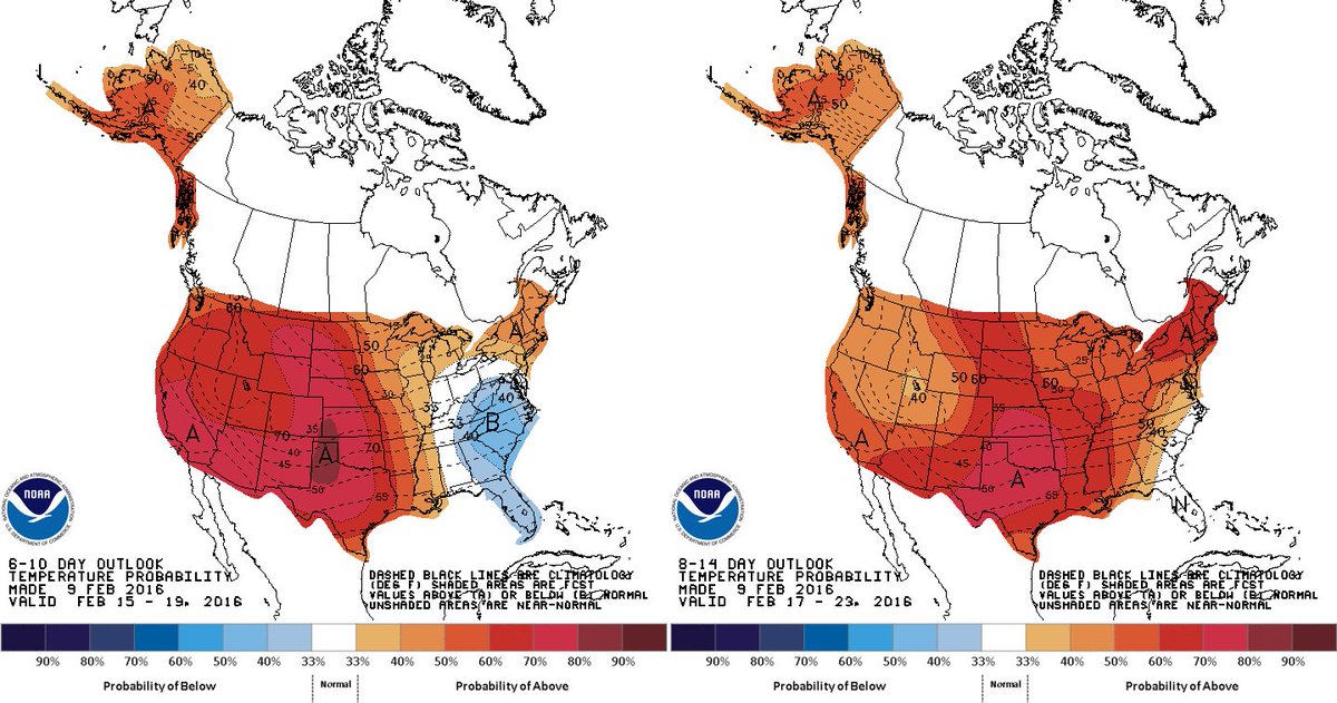 Stronger signal for a milder than average period overall coming for Feb 15 - 23rd. _ |
|
|
|
|
Feb 11 2016, 03:13 PM
Post
#687
|
|
|
Really Comfortable Group: Members Posts: 1,177 Joined: 19-November 09 Member No.: 969 |
Winter Weather Advisory Counties affected: Elkhart; La Porte; St. Joseph Expires 4:00 PM on Saturday, February 13th 2016 Winter Weather Advisory issued February 11 at 3:30PM EST until February 13 at 4:00PM EST by NWS NorthernIndiana ...WINTER WEATHER ADVISORY IN EFFECT FROM 7 AM EST /6 AM CST/ FRIDAY TO 4 PM EST /3 PM CST/ SATURDAY... THE NATIONAL WEATHER SERVICE IN NORTHERN INDIANA HAS ISSUED A WINTER WEATHER ADVISORY...WHICH IS IN EFFECT FROM 7 AM EST /6 AM CST/ FRIDAY TO 4 PM EST /3 PM CST/ SATURDAY. HAZARDOUS WEATHER... * SNOW SHOWERS WILL DEVELOP FRIDAY AS AN ARCTIC COLD FRONT MOVES THROUGH THE AREA. THE SNOW SHOWERS WILL TRANSITION TO LAKE EFFECT SNOW BY FRIDAY EVENING WHICH WILL CONTINUE THROUGH SATURDAY AFTERNOON. * INCREASING WINDS ARE EXPECTED TO CAUSE AREAS OF BLOWING AND DRIFTING SNOW. * TOTAL SNOW ACCUMULATIONS FRIDAY THROUGH SATURDAY ARE EXPECTED TO BE 4 TO 7 INCHES WITH LOCALLY HIGHER AMOUNTS POSSIBLE. * WIND CHILLS WILL FALL TO AS LOW AS 5 BELOW TO 10 BELOW. IMPACTS... * SNOW COVERED SLICK ROADS AND LOW VISIBILITIES DUE TO FALLING AND BLOWING SNOW WILL RESULT IN HAZARDOUS DRIVING CONDITIONS. * FROSTBITE WILL BE POSSIBLE FOR ANYONE WHO IS OUTSIDE FOR PROLONGED PERIODS FRIDAY NIGHT AND SATURDAY. |
|
|
|
|
Feb 19 2016, 08:22 AM
Post
#688
|
|
|
Really Comfortable Group: Members Posts: 1,177 Joined: 19-November 09 Member No.: 969 |
Wind Advisory Counties affected: Adams; Allen; Blackford; Cass; De Kalb; Elkhart; Fulton; Grant; Huntington; Jay; Kosciusko; La Porte; Lagrange; Marshall; Miami; Noble; Pulaski; St. Joseph; Starke; Steuben; Wabash; Wells; White; Whitley Expires 7:00 PM on Friday, February 19th 2016 Wind Advisory issued February 19 at 3:41AM EST until February 19 at 7:00PM EST by NWS NorthernIndiana ...WIND ADVISORY NOW IN EFFECT FROM 9 AM EST /8 AM CST/ THIS MORNING TO 7 PM EST /6 PM CST/ THIS EVENING... THE WIND ADVISORY IS NOW IN EFFECT FROM 9 AM EST /8 AM CST/ THIS MORNING TO 7 PM EST /6 PM CST/ THIS EVENING. HAZARDOUS WEATHER... * SOUTHWEST WINDS TO 30 MPH WITH GUSTS BETWEEN 45 AND 50 MPH. A FEW HIGHER GUSTS ARE POSSIBLE IN ISOLATED AREAS. IMPACTS... * HIGH PROFILE VEHICLES WILL ENCOUNTER STRONG CROSS WINDS. * SCATTERED TREE AND POWER LINE DAMAGE IS POSSIBLE. |
|
|
|
|
Feb 19 2016, 02:41 PM
Post
#689
|
|
|
Really Comfortable Group: Members Posts: 1,177 Joined: 19-November 09 Member No.: 969 |
UPDATE: Winds knocking out power in the Region Lauri Harvey Keagle VALPARAISO — Close to 5,000 NIPSCO customers in the Valparaiso area were without power early Friday and high winds are to blame, representatives said. "Winds are giving us some challenges," Rick Calinski, spokesman for NIPSCO, said. Downed trees, tree limbs and broken poles caused a number of scattered outages in the Valparaiso area, Calinski said. Some of the limbs fell on circuits. Restoration estimates were not immediately known. The power outages have many traffic signals in Valparaiso out as well, which was causing traffic backups. The intersections of Calumet Avenue and Burlington Beech Road and Calumet Avenue and Bullseye Lake Road was heavily impacted by the outages, motorists said. Other outages in the Region were few and widely scattered. The winds caused problems for South Shore trains as well. Trains were delayed Friday afternoon due to the need to reduce speeds in the strong winds and eastbound train No. 9 was stopped just before 2 p.m. just east of the Gary Metro Station due to a gate being stuck in wires. |
|
|
|
|
Feb 23 2016, 06:53 AM
Post
#690
|
|
|
Really Comfortable Group: Members Posts: 1,177 Joined: 19-November 09 Member No.: 969 |
Winter Storm Watch Counties affected: Cass; Elkhart; Fulton; Kosciusko; La Porte; Marshall; Pulaski; St. Joseph; Starke; White Expires 4:00 PM on Thursday, February 25th 2016 Winter Storm Watch issued February 23 at 3:57AM EST until February 25 at 4:00PM EST by NWS NorthernIndiana ...WINTER STORM WATCH IN EFFECT FROM WEDNESDAY MORNING THROUGH THURSDAY AFTERNOON... THE NATIONAL WEATHER SERVICE IN NORTHERN INDIANA HAS ISSUED A WINTER STORM WATCH...WHICH IS IN EFFECT FROM WEDNESDAY MORNING THROUGH THURSDAY AFTERNOON. HAZARDOUS WEATHER... * A MIX OF RAIN AND SNOW CHANGING TO ALL SNOW LATE WEDNESDAY MORNING THROUGH WEDNESDAY AFTERNOON...AND CONTINUING INTO THURSDAY. * STORM TOTAL SNOWFALL ACCUMULATIONS OF 4 TO 8 INCHES EXPECTED BY LATE THURSDAY AFTERNOON. * THE HEAVIEST SNOWFALL IS EXPECTED WEDNESDAY AFTERNOON INTO WEDNESDAY NIGHT. * NORTH WINDS WILL INCREASE TO 20 TO 30 MPH ON WEDNESDAY AND SHIFT TO THE NORTHWEST WEDNESDAY NIGHT AND THURSDAY. GUSTS TO 35 TO 40 MPH ARE POSSIBLE WEDNESDAY EVENING INTO THURSDAY CAUSING SOME BLOWING AND DRIFTING SNOW AND REDUCED VISIBILITIES. IMPACTS... * HAZARDOUS TRAVEL CONDITIONS ARE POSSIBLE WEDNESDAY AND THURSDAY. THE WEDNESDAY EVENING AND THURSDAY MORNING COMMUTES MAY BE IMPACTED. * SOME SCATTERED TREE DAMAGE IS POSSIBLE DUE TO THE COMBINATION OF WET...HEAVY SNOW AND STRONG NORTH WINDS. * ROADS WILL BECOME SNOW COVERED AND SLICK. |
|
|
|
|
Feb 24 2016, 07:41 AM
Post
#691
|
|
|
Really Comfortable Group: Members Posts: 1,177 Joined: 19-November 09 Member No.: 969 |
  Blizzard Warning Counties affected: Fulton; La Porte; Marshall; Pulaski; St. Joseph; Starke; White Expires 10:00 PM on Wednesday, February 24th 2016 Blizzard Warning issued February 24 at 5:29AM EST until February 24 at 10:00PM EST by NWS NorthernIndiana ...BLIZZARD LIKELY TO MAKE TRAVEL NEARLY IMPOSSIBLE TODAY INTO THIS EVENING OVER NORTHWEST INDIANA... ...BLIZZARD WARNING IN EFFECT FROM 8 AM EST /7 AM CST/ THIS MORNING TO 10 PM EST /9 PM CST/ THIS EVENING... ...WINTER STORM WARNING NOW IN EFFECT FROM 10 PM EST /9 PM CST/ THIS EVENING TO 4 PM EST /3 PM CST/ THURSDAY... THE NATIONAL WEATHER SERVICE IN NORTHERN INDIANA HAS ISSUED A BLIZZARD WARNING...WHICH IS IN EFFECT FROM 8 AM EST /7 AM CST/ THIS MORNING TO 10 PM EST /9 PM CST/ THIS EVENING. THE WINTER STORM WARNING IS NOW IN EFFECT FROM 10 PM EST /9 PM CST/ THIS EVENING TO 4 PM EST /3 PM CST/ THURSDAY. HAZARDOUS WEATHER... * SNOW...HEAVY AT TIMES...WILL DEVELOP THIS MORNING POSSIBLY BEGINNING AS A BRIEF PERIOD OF FREEZING RAIN. BLIZZARD CONDITIONS ARE MOST LIKELY FROM MID MORNING THROUGH MID EVENING. * STORM TOTAL SNOWFALL ACCUMULATIONS OF 8 TO 12 INCHES ARE EXPECTED BY LATE THURSDAY AFTERNOON. LOCALLY HIGHER ACCUMULATIONS ARE POSSIBLE. SNOWFALL RATES OF 1 TO AS MUCH AS 2 INCHES PER HOUR ARE LIKELY FROM MID MORNING THROUGH MID EVENING. * NORTH WINDS WILL INCREASE TO 20 TO 30 MPH WILL SHIFT TO THE NORTHWEST THIS EVENING. GUSTS OF 40 TO 45 MPH WILL RESULT IN NEAR ZERO VISIBILITY AND WHITE OUT CONDITIONS AT TIMES...ESPECIALLY IN RURAL AREAS FROM LATE MORNING THROUGH MID EVENING. IMPACTS... * TRAVEL CONDITIONS ARE EXPECTED TO DETERIORATE QUICKLY THIS MORNING...WITH THE MOST HAZARDOUS CONDITIONS OCCURRING FROM LATE MORNING THROUGH MID EVENING WHEN TRAVEL MAY BECOME IMPOSSIBLE. * SCATTERED TREE AND POWER LINE DAMAGE IS LIKELY DUE TO THE COMBINATION OF HEAVY...WET SNOW AND STRONG WINDS LEADING TO POWER OUTAGES. |
|
|
|
|
Feb 24 2016, 08:48 AM
Post
#692
|
|
|
Really Comfortable Group: Members Posts: 1,177 Joined: 19-November 09 Member No.: 969 |
UPDATE: Visibility near zero as blizzard blows in Times Staff Area officials have a simple message for folks in the Region today: Stay home. "If you must go out, make sure you fully clear off your vehicle," Sgt. Ann Wojas of Indiana State Police said. "That includes front and rear windshields and side mirrors." Snow began falling in parts of the Region around 7 a.m. and forecasters said the worst is yet to come. The snowfall rates began increasing by 8 a.m., with visibility becoming reduced to near zero in some areas. Many schools closed Wednesday as the Region prepared for a blizzard that could dump as much as 18 inches of snow on the ground and make travel impossible. The National Weather Service issued a blizzard warning for Lake, Porter, LaPorte, Newton, Jasper and Benton counties. The warning in Lake, Porter and LaPorte counties runs from 9 a.m. to midnight. In LaPorte County, the warning extends from 7 a.m. Wednesday to 3 p.m. Thursday. The Newton and Jasper county warning runs from 6 a.m. to 9 p.m. The blizzard may begin with brief periods of rain before switching over to all snow. Forecasters said blizzard-like conditions are likely to begin in the mid- to late morning and improve by mid- to late evening. Snowfall totals are expected to be between 8 and 14 inches but could reach as high as 18 inches in some areas. Winds are expected to be 25 to 40 mph with gusts of up to 50 mph. The heavy, wet snow and winds will cause visibilities of zero, creating total white out conditions. The National Weather Service said travel should be avoided. Forecasters warned that shoveling heavy, wet snow can lead to over-exertion and cardiac distress. The heavy, wet snow combined with strong winds can also lead to downed trees, tree limbs and power lines. NIPSCO said in a statement Tuesday night it was preparing for the storm by increasing staffing at call centers, scheduling extra work crews, postponing scheduled work that would cause equipment to be unavailable, putting work crews in the field to monitor the system and respond quickly to problems, and remaining in contact with local public officials about potential problems. The utility also asked residents to avoid downed power lines and report outages by calling (800) 464-7726, texting "out" to 444111 or going to NIPSCO.com A lakeshore flood warning is also in effect in Lake, Porter and LaPorte counties, where waves could reach 12 to 18 feet. The Indiana Toll Road issued a ban on all triples, long-doubles, high-profile and over-size loads and steel haulers in anticipation of the weather. Wojas of the Indiana State Police for the Lowell District urged motorists who must venture out today to be prepared in case of emergency. "Use your low-beam lights, fill your gas tank and charge your mobile phone," Wojas said. "Have a vehicle emergency kit-non-perishable food, water bottles, blanket, shovel, snow scraper, flashlight and extra batteries, road salt, sand or kitty litter and booster cables." Lieutenant Terry Gose, Commander of the ISP Lowell Post, urged drivers to keep the safety of troopers in mind today as well. "We will have all available troopers out working today," Gose said. "Please keep our emergency personnel in mind if you’re traveling today that means for motorists to approach cautiously when they see an emergency vehicle stopped with its emergency lights on. Change lanes away from the emergency vehicle if you can do so safely. "If not, reduce your speed 10 mph and proceed with caution. Do not stop in the roadway. This may cause a chain-reaction, rear-end crash with other vehicles." Doug Moats, spokesman for the Indiana Department of Transportation's LaPorte District, said crews from other parts of the district were heading north to help keep the roads clear and safe. Moats said ramps and bridges were beginning to get slick around 8 a.m. Nearly 900 flights were cancelled in and out of Chicago as a result of the weather as well, according to FlightAware.com. Check back often with nwi.com for updates. |
|
|
|
|
Feb 24 2016, 09:35 AM
Post
#693
|
|
 Spends WAY too much time at CBTL Group: Admin Posts: 16,425 Joined: 8-December 06 From: Michigan City, IN Member No.: 2 |
This is going to be the storm of the year.
|
|
|
|
|
Feb 24 2016, 10:06 AM
Post
#694
|
|
|
Really Comfortable Group: Members Posts: 1,177 Joined: 19-November 09 Member No.: 969 |
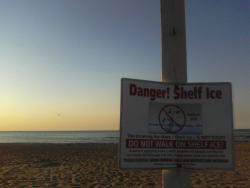
 Lakeshore Flood Warning Counties affected: La Porte Expires 10:00 PM on Thursday, February 25th 2016 Lakeshore Flood Warning issued February 24 at 5:35AM EST until February 25 at 10:00PM EST by NWS NorthernIndiana ...LAKESHORE FLOOD WARNING REMAINS IN EFFECT FROM 1 PM EST /NOON CST/ THIS AFTERNOON TO 10 PM EST /9 PM CST/ THURSDAY... * LAKE SHORE FLOODING...NORTH WINDS AROUND 40 MPH WITH GUSTS OF 50 TO 60 MPH THIS AFTERNOON AND TONIGHT WILL BECOME NORTHWEST ON THURSDAY CAUSING 12 TO 18 FOOT WAVES ALONG THE LAPORTE AND BERRIEN COUNTY SHORELINES. THIS PROLONGED PERIOD OF HIGH WAVES WITH ONSHORE FLOW...COMBINED WITH HIGHER THAN NORMAL LAKE MICHIGAN WATER LEVELS...WILL RESULT IN SIGNIFICANT LAKESHORE FLOODING AND BEACH EROSION ALONG THE BERRIEN AND LAPORTE COUNTY LAKE MICHIGAN SHORELINES. * IMPACTS...FLOODING AND SIGNIFICANT BEACH EROSION WILL IMPACT LAPORTE AND BERRIEN COUNTY BEACHES. ROADS AND HOMES ALONG THE SHORELINE MAY ALSO BE IMPACTED. THE HIGH WAVES WILL WASH OVER PIERS. |
|
|
|
|
Feb 24 2016, 01:44 PM
Post
#695
|
|
|
Really Comfortable Group: Members Posts: 1,177 Joined: 19-November 09 Member No.: 969 |
 UPDATE: Roads hazardous as blizzard conditions persist Times Staff Area officials have a simple message for folks in the Region today: Stay home. "If you must go out, make sure you fully clear off your vehicle," Sgt. Ann Wojas of Indiana State Police said. "That includes front and rear windshields and side mirrors." Snow began falling in parts of the Region around 7 a.m. The snowfall rates began increasing by 8 a.m., with visibility becoming reduced to near zero in some areas. Indiana State Police responded to multiple slide-off and spin-out crashes on all area expressways and on the Indiana Toll Road Wednesday. All South Shore trains were expected to be delayed 10 to 20 minutes Wednesday due to the blizzard. Northern Indiana Commuter Transportation representatives advised passengers to be at their departing stations on time in case the delays are reduced. The Indiana Toll Road issued a ban on all triples, long-doubles, high-profile and over-size loads and steel haulers in anticipation of the weather. Wojas urged motorists who must venture out today to be prepared in case of emergency. "Use your low-beam lights, fill your gas tank and charge your mobile phone," Wojas said. "Have a vehicle emergency kit-non-perishable food, water bottles, blanket, shovel, snow scraper, flashlight and extra batteries, road salt, sand or kitty litter and booster cables." Lieutenant Terry Gose, Commander of the ISP Lowell Post, urged drivers to keep the safety of troopers in mind today as well. "We will have all available troopers out working today," Gose said. "Please keep our emergency personnel in mind if you’re traveling today that means for motorists to approach cautiously when they see an emergency vehicle stopped with its emergency lights on. Change lanes away from the emergency vehicle if you can do so safely. "If not, reduce your speed 10 mph and proceed with caution. Do not stop in the roadway. This may cause a chain-reaction, rear-end crash with other vehicles." Doug Moats, spokesman for the Indiana Department of Transportation's LaPorte District, said roads were snow-covered and slick throughout the Region at 11 a.m. "INDOT plow/salt crews have been attacking this winter storm since early this morning, before the first flake fell, with salt, sand, and plows," Moats said. "Crews will remain in full call-out, 24 hour a day, until the storm passes and roads are clear."' Moats said INDOT is bringing in crews from Southern Indiana to help battle the blizzard. "Despite our best efforts, conditions will be dangerous," he said. "If you must drive, slow down, don’t follow too closely, brake early, and drive to the conditions on the roads. It is unsafe to travel the speed limit in conditions like these." Many schools closed Wednesday as the Region prepared for the blizzard forecasters said could dump as much as 18 inches of snow on the ground and make travel impossible. One Region school corporation that chose to stay open was Valparaiso Community Schools, which upset several parents. "I have gotten a lot of calls from people disagreeing with my decision and that happens every time we have a situation like this," Superintendent E. Ric Frataccia said. "It never feels good to have parents mad at you but I made the decision because I didn't think the kids would be in danger." Frataccia said school officials began discussions on plans for the school day at 5 a.m. with buildings and grounds and busing staff. "We also talked to the Valparaiso utilities people and roads people," he said. "They did not foresee any problems in bringing the students in." Just before noon, Frataccia said he received information from city officials indicating road conditions were deteriorating and that drivers were being encouraged to stay off the roads. Frataccia said after discussing the issue with bus managers, the decision was made to dismiss high school students at 1 p.m. and middle school students at 2 p.m. The elementary students will be dismissed at 2:45 p.m. Lake County Commissioner Gerry Scheub, D-Crown Point, announced shortly after 9 a.m. that the Lake County Government Center in Crown Point and satellite courthouses in Gary, Hammond and East Chicago would close at 9:30 a.m. Wednesday and not reopen before 8:30 a.m. Thursday due to the blizzard. Scheub said county officials decided on the closure after receiving the latest forecast. Mark Back, spokesman for the Lake County Sheriff's Department, said many county roads were impassable Wednesday morning. "The Lake County Sheriff's Department is urging all residents of Lake County to stay home and off the roads if at all possible during these dangerous winter conditions," Back said. "All roads are currently hazardous and drivers should observe the highest level of caution if travel is necessary." All Porter County government offices planned to close at noon due to the weather. Porter County officials reported roads were becoming hazardous and slick with numerous slide-off and spin-out crashes around 1 p.m. People were advised to stay off the roads there if at all possible. The National Weather Service issued a blizzard warning for Lake, Porter, LaPorte, Newton, Jasper and Benton counties. The warning in Lake, Porter and LaPorte counties runs from 9 a.m. to midnight. In LaPorte County, the warning extends from 7 a.m. Wednesday to 3 p.m. Thursday. The Newton and Jasper county warning runs from 6 a.m. to 9 p.m. Snowfall totals are expected to be between 8 and 14 inches but could reach as high as 18 inches in some areas. Winds are expected to be 25 to 40 mph with gusts of up to 50 mph. The heavy, wet snow and winds will cause visibility to be near zero and total white out conditions. The National Weather Service said travel should be avoided. Forecasters warned that shoveling heavy, wet snow can lead to over-exertion and cardiac distress. The heavy, wet snow combined with strong winds can also lead to downed trees, tree limbs and power lines. NIPSCO began experiencing power outages as a result of the blizzard early Wednesday afternoon. As of 1:15 p.m., some 7,000 NIPSCO customers were without power throughout the northern service area, which covers about the top third of the state. Most of the outages were concentrated in Portage and Lowell. The utility also asked residents to avoid downed power lines and report outages by calling (800) 464-7726, texting "out" to 444111 or going to NIPSCO.com A lakeshore flood warning is also in effect in Lake, Porter and LaPorte counties, where waves could reach 12 to 18 feet. Many local officials reminded residents of the snow route parking restrictions in place in area communities as well. More than 1,000 flights were cancelled in and out of Chicago as a result of the weather as well, according to FlightAware.com. Southwest Airlines cancelled all flights in and out of Midway due to weather conditions as well. |
|
|
|
|
Feb 24 2016, 11:38 PM
Post
#696
|
|
|
Advanced Member Group: Members Posts: 298 Joined: 18-March 14 Member No.: 1,324 |
6 inches here last I measured. Seems like though we dodged the worst. State of emergency declared in Lake and Porter County. Suprised City is only under a delay, Bet that changes in the morning. 15702 people without power in Nipsco area but only 189 in City.
|
|
|
|
|
Feb 25 2016, 06:54 AM
Post
#697
|
|
|
Really Comfortable Group: Members Posts: 1,177 Joined: 19-November 09 Member No.: 969 |
All South Shore service stopped due to blizzard damage
Lauri Harvey Keagle The Northern Indiana Commuter Transportation District suspended all South Shore train service due to blizzard damage, representatives announced early Thursday. "Last evening, a NIPSCO conductor failed near State Road 249 bridge in Porter County, threatening our overhead power distribution system and preventing our trains from traveling through the affected area," NICTD Spokesman John Parsons said. Parsons said the blizzard also cut power to the grade crossing warning devices between Grant Street and Waverly Road in Porter County, impacting 18 crossings. That outage caused delays to rush hour and late evening trains and cancelled Train No. 123, which was scheduled to leave Chicago at 11:00 p.m. "Until NIPSCO makes emergency repairs to its circuit at (the) State Road 249 bridge and reestablishes power to our grade crossing warning devices, we are unable to restore train service," Parsons said. "We apologize for any inconvenience ... We are committed to restoring service as soon as it is safe to do so." Metra will honor South Shore tickets on the Metra Electric District Line Thursday. UPDATES: http://www.nictd.com/ _ |
|
|
|
|
Feb 25 2016, 09:53 AM
Post
#698
|
|
|
Really Comfortable Group: Members Posts: 1,177 Joined: 19-November 09 Member No.: 969 |
UPDATE: South Shore service to resume later today
South Shore train service is scheduled to resume just after 10 a.m. following the suspension of all trains early Thursday due to NIPSCO damage caused by the blizzard, representatives said. "NIPSCO repairs have been made and the South Shore expects to resume its regular westbound passenger service schedule with the departure of Train 216 from Gary Metro Center at 10:12 a.m.," Northern Indiana Commuter Transportation District spokesman John Parsons said. Regular eastbound service will resume with the departure of Train No. 9 from Millennium Station at 12:35 p.m. Midday passengers may encounter delays, Parsons said. Parsons said earlier the suspension of service was caused by a NIPSCO conductor that failed near the Ind. 249 bridge in Porter County Wednesday night, "threatening our overhead power distribution system and preventing our trains from traveling through the affected area." Parsons said the blizzard also cut power to the grade crossing warning devices between Grant Street and Waverly Road in Porter County, impacting 18 crossings. Metra honored South Shore tickets on the Metra Electric District Line Thursday. |
|
|
|
|
Feb 25 2016, 10:15 AM
Post
#699
|
|
|
Really Comfortable Group: Members Posts: 1,177 Joined: 19-November 09 Member No.: 969 |
No wonder I couldn't open the door this morning.
http://chicagoweathercenter.com/blog/snow-...rthwest-indiana _ |
|
|
|
|
Feb 29 2016, 02:52 PM
Post
#700
|
|
|
Really Comfortable Group: Members Posts: 1,177 Joined: 19-November 09 Member No.: 969 |
Winter Weather Advisory Counties affected: Elkhart; La Porte; Lagrange; St. Joseph; Steuben Expires 1:00 AM on Wednesday, March 2nd 2016 Winter Weather Advisory issued February 29 at 3:01PM EST until March 02 at 1:00AM EST by NWS NorthernIndiana ...WINTER WEATHER ADVISORY IN EFFECT FROM 1 AM EST /MIDNIGHT CST/ TUESDAY TO 1 AM EST /MIDNIGHT CST/ WEDNESDAY... THE NATIONAL WEATHER SERVICE IN NORTHERN INDIANA HAS ISSUED A WINTER WEATHER ADVISORY...WHICH IS IN EFFECT FROM 1 AM EST /MIDNIGHT CST/ TUESDAY TO 1 AM EST /MIDNIGHT CST/ WEDNESDAY. HAZARDOUS WEATHER... * A WINTRY MIX OF FREEZING RAIN AND SNOW WILL DEVELOP OVERNIGHT AND CONTINUE INTO TUESDAY. PRECIPITATION IS EXPECTED TO CHANGE TO ALL SNOW BY EARLY TUESDAY AFTERNOON. * TOTAL SNOWFALL AMOUNTS OF 2 TO 4 INCHES ARE POSSIBLE ACROSS MICHIGAN WHILE 1 TO 3 INCHES ARE POSSIBLE IN INDIANA BY TUESDAY EVENING. ICE ACCUMULATIONS OF UP TO A TENTH OF AN INCH ARE POSSIBLE. * LIGHT PRECIPITATION IS EXPECTED LATE TONIGHT FROM NEAR THE INDIANA AND MICHIGAN STATE LINE NORTHWARD. PRECIPITATION IS EXPECTED TO EXPAND FURTHER INTO INDIANA TOWARD OR SHORTLY AFTER DAYBREAK TUESDAY. IMPACTS... * ROADS WILL BECOME SNOW OR ICE COVERED...SLICK AND HAZARDOUS ESPECIALLY TUESDAY MORNING. * THE TUESDAY MORNING COMMUTE MAY BE IMPACTED BY MIXED PRECIPITATION WHILE THE EVENING COMMUTE WILL BE MAINLY FROM SNOW. |
|
|
|
|
2 User(s) are reading this topic (2 Guests and 0 Anonymous Users)
0 Members:
| Lo-Fi Version | Time is now: 27th April 2024 - 11:03 PM |
Skin Designed By: neo at www.neonetweb.com
Invision Power Board
v2.1.7 © 2024 IPS, Inc.