
  |

 Apr 16 2011, 04:14 PM Apr 16 2011, 04:14 PM
Post
#81
|
|
 Really Comfortable  Group: Members Posts: 2,005 Joined: 6-July 09 From: In Front of a computer screen Member No.: 929 |
It's snowing outside!!!
 |
   |

 
|
|
Apr 16 2011, 07:24 PM
Post
#82
|
|
|
Really Comfortable Group: Members Posts: 627 Joined: 9-February 07 Member No.: 41 |
QUOTE(taxthedeer @ Apr 16 2011, 05:14 PM)  It's snowing outside!!! Shhhhh! Watch the four letter words please. |
|
|
|
|
Apr 18 2011, 08:14 AM
Post
#83
|
|
 Spends WAY too much time at CBTL Group: Admin Posts: 16,425 Joined: 8-December 06 From: Michigan City, IN Member No.: 2 |
QUOTE(taxthedeer @ Apr 16 2011, 05:14 PM) It's snowing outside!!! I can't think of more appropriate weather for tax day honestly... |
|
|
|
|
Apr 26 2011, 12:16 PM
Post
#84
|
|
|
Spends WAY too much time at CBTL Group: Admin Posts: 16,425 Joined: 8-December 06 From: Michigan City, IN Member No.: 2 |
More weather fun... I hope you have those arks built!
Tom Skilling Latest Wed/Thu precip numbers off the Weather Service's 7am Tue run of the WRF model are: 1.62" Lakefront, 2.09" O'Hare & 2.02" Midway! Here's a plot of the predicted Wed into Thu rain event. Tom Skilling The hyper-active Spring 2011 severe weather season rolls on with another tornado outbreak predicted for a wide area of the country south & east of Chicago. Here's the "tornado ingredients" panel verifying at 4 pm Tue afternoon from the Storm Prediction Center. This fcst outlines the area where atmospheric energy (high "CAPES"), spin ("helicity") and shear threaten rotating supercells and twister development. SPC has logged 751 tornado reports to date which will be culled down to the number of actual tornadoes at a future date. The 3 yr avg of twisters thru April acrs the US is 378. From -- WSBT-TV A stormy afternoon and evening is on the way, with some hail and wind possible with the storms. I'll be Storm Tracking throughout the day and on WSBT News tonight. |
|
|
|
|
Apr 26 2011, 01:57 PM
Post
#85
|
|
|
Spends WAY too much time at CBTL Group: Admin Posts: 16,425 Joined: 8-December 06 From: Michigan City, IN Member No.: 2 |
|
|
|
|
|
Apr 26 2011, 02:13 PM
Post
#86
|
|
 Really Comfortable Group: Members Posts: 1,177 Joined: 19-November 09 Member No.: 969 |
QUOTE(southsiderMMX @ Apr 26 2011, 02:57 PM) Nothin showin up yet on the weathercenter: http://www.chicagoweathercenter.com/maps/alerts/ |
|
|
|
|
May 13 2011, 12:14 PM
Post
#87
|
|
|
Spends WAY too much time at CBTL Group: Admin Posts: 16,425 Joined: 8-December 06 From: Michigan City, IN Member No.: 2 |
Get to where you are going soon, because it looks like City is in the thunderstorm bullseye again. Big storms have popped off to our south and southwest and seem to be headed this way!
|
|
|
|
|
May 13 2011, 12:15 PM
Post
#88
|
|
|
Spends WAY too much time at CBTL Group: Admin Posts: 16,425 Joined: 8-December 06 From: Michigan City, IN Member No.: 2 |
There are tornado warnings in two counties south of Chicago right now
|
|
|
|
|
May 22 2011, 09:24 AM
Post
#89
|
|
|
Really Comfortable Group: Members Posts: 1,177 Joined: 19-November 09 Member No.: 969 |
Primary tornado threat just west of Chicago
May 22, 2011 7:13 AM | by Mike Hamernik http://twitter.com/#!/MikeHamernik The Storm Prediction Center is indicating a severe weather outbreak is possible this afternoon and evening over portions of the Midwest. Thunderstorms that roll into Chicago this evening have the potential to produce damaging winds, large hail and nearly continuous lightning. In addition, a few tornadoes will be possible. The area most susceptible to tornadic thunderstorms will be just west of Chicago, over western Illinois, eastern Iowa and western Wisconsin. BELOW: Areas highlighted below signify where the highest probability of a significant tornado will lie at 4PM (figure 1 at 2100z) and 7PM (figure 2 at 0000z).  |
|
|
|
|
May 22 2011, 11:45 AM
Post
#90
|
|
|
Really Comfortable Group: Members Posts: 2,005 Joined: 6-July 09 From: In Front of a computer screen Member No.: 929 |
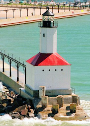
Better batten down the hatch.
I really like your avatar with with Lighthouse, pier, catwalk, Marina, Trail Creek and Lake Michigan. |
|
|
|
|
May 25 2011, 06:42 AM
Post
#91
|
|
|
Spends WAY too much time at CBTL Group: Admin Posts: 16,425 Joined: 8-December 06 From: Michigan City, IN Member No.: 2 |
http://chicago.cbslocal.com/2011/05/25/sev...n-chicago-area/
QUOTE CHICAGO (CBS) — Severe weather is hitting the Chicago area this morning, with heavy rain and lightning across much of the area. A Tornado watch is in effect for several counties, including Will, Kankakee, LaSalle, Livingston, Grundy, Iroquois and Kendall counties. The watch is in effect until 1 p.m. As of 7:30 a.m., strong storms were hitting areas around Kankakee, Joliet and Aurora. The line of storms continued to move toward the southern suburbs of Chicago. Northwest Indiana was also getting some heavy rainfall. CBS 2 meteorologist Megan Glaros reports that cooler air near Chicago may help lessen the severity of the storms as they head in a northeasterly direction. While rain began to fall around 7:30 on the South Side, Chicago can expect heavier rain around 8 a.m. The strongest thunderstorms may produce nickel-size hail, frequent cloud-to-ground lightning, wind gusts of more than 60 mph and perhaps an isolated tornado After the morning round of storms, there will be a break in the heavy rain. However, there is a good chance of more severe weather Wednesday evening, Glaros said. |
|
|
|
|
May 25 2011, 07:58 AM
Post
#92
|
|
|
Spends WAY too much time at CBTL Group: Admin Posts: 16,425 Joined: 8-December 06 From: Michigan City, IN Member No.: 2 |
THE NATIONAL WEATHER SERVICE HAS ISSUED TORNADO WATCH 368 IN EFFECT UNTIL 7 PM EDT /6 PM CDT/ THIS EVENING FOR THE FOLLOWING AREAS
IN INDIANA THIS WATCH INCLUDES 24 COUNTIES IN NORTHERN INDIANA ADAMS ALLEN IN BLACKFORD CASS IN DE KALB ELKHART FULTON IN GRANT HUNTINGTON JAY KOSCIUSKO LA PORTE LAGRANGE MARSHALL MIAMI NOBLE PULASKI ST. JOSEPH IN STARKE STEUBEN WABASH WELLS WHITE WHITLEY |
|
|
|
|
May 25 2011, 08:44 AM
Post
#93
|
|
|
Spends WAY too much time at CBTL Group: Admin Posts: 16,425 Joined: 8-December 06 From: Michigan City, IN Member No.: 2 |
Tom Skilling
Storm damage reported in Newton Co IN at 9:25 am-possible funnel cloud. Shed heeavily damaged, utility poles reported down near state road 55 and 114. |
|
|
|
|
May 25 2011, 09:08 AM
Post
#94
|
|
|
Spends WAY too much time at CBTL Group: Admin Posts: 16,425 Joined: 8-December 06 From: Michigan City, IN Member No.: 2 |
Special marine Weather Bulletin issued for Lake Michigan between Gary and Michigan City. High winds, hail and water spouts are possible in this area until 11:30 a.m.
|
|
|
|
|
May 25 2011, 09:30 AM
Post
#95
|
|
|
Really Comfortable Group: Members Posts: 1,177 Joined: 19-November 09 Member No.: 969 |
Tornado sirens have been BLASTING in Westville all morning today.
|
|
|
|
|
May 25 2011, 12:48 PM
Post
#96
|
|
|
Spends WAY too much time at CBTL Group: Admin Posts: 5,171 Joined: 11-December 06 From: Indiana Member No.: 10 |
 Be who you are and say what you feel because those who mind don't matter and those who matter don't mind~Dr. Suess
|
|
|
|
|
May 25 2011, 01:03 PM
Post
#97
|
|
|
Really Comfortable Group: Members Posts: 1,177 Joined: 19-November 09 Member No.: 969 |
QUOTE(Ang @ May 25 2011, 01:48 PM) QUOTE CBS 2 meteorologist Megan Glaros reports that cooler air near Chicago may help lessen the severity of the storms as they head in a northeasterly direction. Well thats a relief.  |
|
|
|
|
May 25 2011, 07:05 PM
Post
#98
|
|
|
Advanced Member Group: Members Posts: 459 Joined: 4-April 07 Member No.: 182 |
QUOTE(Ang @ May 25 2011, 01:48 PM) Get ready for round two... By my rain gauge, we got 1.25" from round 1. Put simply, mean reversion is a bitch. -Vitaliy Katsenelson
|
|
|
|
|
May 27 2011, 09:49 AM
Post
#99
|
|
|
Spends WAY too much time at CBTL Group: Admin Posts: 16,425 Joined: 8-December 06 From: Michigan City, IN Member No.: 2 |
http://thenewsdispatch.com/articles/2011/0...7e143058049.txt
QUOTE NIPSCO: Storms briefly knock out power By Tim Moran Staff Writer Published: Thursday, May 26, 2011 5:09 PM CDT MICHIGAN CITY — Wednesday morning’s storm saw nearly 250 Michigan City NIPSCO customers without power for a few hours. “There were scattered outages throughout NIPSCO’s service area as a result of the high winds and storms,” Nick Meyer, NIPSCO director of external communications, said Wednesday afternoon. “Most of the outages occurred between the 8 and 9 a.m. time frame, and all of those were restored within a few short hours.” As of 4 p.m., Meyer said, there were three customers without power in La Porte County, including one in Michigan City as a result of a “tree limb that fell on a power line.” Nearly 3,000 customers in all of NIPSCO’s coverage area were left without power throughout the day. |
|
|
|
|
May 29 2011, 12:46 PM
Post
#100
|
|
|
Spends WAY too much time at CBTL Group: Admin Posts: 16,425 Joined: 8-December 06 From: Michigan City, IN Member No.: 2 |
Tornado sirens are sounding in Michigan City as we speak!
|
|
|
|
|
1 User(s) are reading this topic (1 Guests and 0 Anonymous Users)
0 Members:
| Lo-Fi Version | Time is now: 27th April 2024 - 12:48 PM |
Skin Designed By: neo at www.neonetweb.com
Invision Power Board
v2.1.7 © 2024 IPS, Inc.