
  |

 Dec 30 2013, 08:05 PM Dec 30 2013, 08:05 PM
Post
#41
|
|
 Spends WAY too much time at CBTL  Group: Admin Posts: 16,425 Joined: 8-December 06 From: Michigan City, IN Member No.: 2 |
Tom Skilling predicting 9.4 inches in City between tonight and Thursday afternoon.
|
   |

 
|
|
Dec 31 2013, 10:23 AM
Post
#42
|
|
|
Spends WAY too much time at CBTL Group: Admin Posts: 16,425 Joined: 8-December 06 From: Michigan City, IN Member No.: 2 |
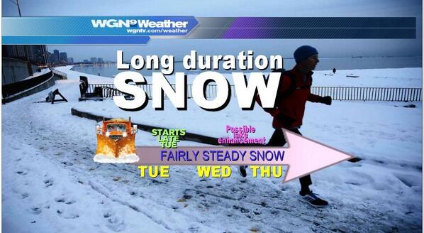
The National Weather Service snow forecast maps have Michigan City in the band of 6 to 9 inches of snow starting tonight and ending Thursday night. The bands are pretty narrow, and the 5 to 7 inch band starts in the south half of LP County. The situation still sounds pretty fluid though, both based on projected path AND projected speed of the system. The highest totals would be seen on a more southerly and slower track. The lowest totals on a northerly and faster track. Stay tuned.
|
|
|
|
|
Dec 31 2013, 11:19 AM
Post
#43
|
|
|
Spends WAY too much time at CBTL Group: Admin Posts: 16,425 Joined: 8-December 06 From: Michigan City, IN Member No.: 2 |
The latest from Tom Skilling's weather blog.
"Snowfall estimates reach 1-3″ by midnight New Year’s Eve (Tuesday night); 3 to 5” by Wednesday morning and could top 10” by Thursday afternoon in a few harder hit lakeside counties" http://blog.chicagoweathercenter.com/2013/...-into-thursday/ |
|
|
|
|
Dec 31 2013, 03:28 PM
Post
#44
|
|
 Really Comfortable Group: Members Posts: 1,177 Joined: 19-November 09 Member No.: 969 |
Its friggin TREACHEROUS out there !
 |
|
|
|
|
Jan 2 2014, 06:29 AM
Post
#45
|
|
|
Really Comfortable Group: Members Posts: 1,177 Joined: 19-November 09 Member No.: 969 |
 LaPorte Winter Weather Advisory: Issued at: 3:38 am CST on January 2, 2014/, expires at: 3:00 PM CST on January 02, 2014 ...Winter Weather Advisory remains in effect until 4 PM EST /3 PM CST/ this afternoon... Hazardous weather... timing...light to moderate snow will diminish through the day...ending across Northwest Ohio late this afternoon. Additional snow accumulations of 1 to 3 inches are possible today. Northeast winds of 10 to 20 mph with gusts to 25 mph will cause blowing and drifting snow. The strongest wind gusts are expected this afternoon. Impacts... roads will be snow covered...slick...and hazardous. Visibilities will also be limited at times this morning. This will make travel across the area difficult. Precautionary/preparedness actions... A Winter Weather Advisory for snow means that periods of snow will cause primarily travel difficulties. Be prepared for snow covered roads and limited visibilities...and use caution while driving. |
|
|
|
|
Jan 2 2014, 08:40 AM
Post
#46
|
|
|
Spends WAY too much time at CBTL Group: Admin Posts: 16,425 Joined: 8-December 06 From: Michigan City, IN Member No.: 2 |
Did you see the temps forecast for next week? YIKES!
|
|
|
|
|
Jan 2 2014, 08:47 AM
Post
#47
|
|
|
Really Comfortable Group: Members Posts: 1,177 Joined: 19-November 09 Member No.: 969 |
Hopefully it will only last two days. Gonna insulate the pipes later on today.
|
|
|
|
|
Jan 2 2014, 08:47 AM
Post
#48
|
|
|
Spends WAY too much time at CBTL Group: Admin Posts: 16,425 Joined: 8-December 06 From: Michigan City, IN Member No.: 2 |
Lighthouse place isn't opening until noon today.
|
|
|
|
|
Jan 2 2014, 09:36 AM
Post
#49
|
|
|
Really Comfortable Group: Members Posts: 1,177 Joined: 19-November 09 Member No.: 969 |
Well it could be alot worse. I actually visited this city once....in the summer of course:
QUOTE In terms of astonishing weather facts, it doesn't get much more impressive than being as cold as a distant planet for a day. The Manitoba Museum is reporting Winnipeg's temperatures on Tuesday were actually as cold as the surface of Mars. http://bit.ly/1cKa5Ih _ |
|
|
|
|
Jan 2 2014, 07:57 PM
Post
#50
|
|
|
Really Comfortable Group: Members Posts: 1,177 Joined: 19-November 09 Member No.: 969 |
 |
|
|
|
|
Jan 4 2014, 02:43 AM
Post
#51
|
|
|
Really Comfortable Group: Members Posts: 1,177 Joined: 19-November 09 Member No.: 969 |
 Winter Storm Watch Expiring: 2014-01-06 06:00:00 Areas affected: Iroquois, IL; Jasper, IN; Kankakee, IL; Kankakee, IL; Kenosha, WI; La Porte, IN; Lake, IN; Newton, IN; Porter, IN; Racine, WI; Walworth, WI; Will, IL; URGENT - WINTER WEATHER MESSAGE NATIONAL WEATHER SERVICE CHICAGO IL 923 PM CST FRI JAN 3 2014 ILZ023-032-033-039-INZ001-002-010-011-019-041130- /O.CON.KLOT.WS.A.0001.140105T0000Z-140106T0600Z/ KANKAKEE-LIVINGSTON-IROQUOIS-FORD-LAKE IN-PORTER-NEWTON-JASPER- BENTON- INCLUDING THE CITIES OF...KANKAKEE...PONTIAC...WATSEKA...PAXTON... GARY...VALPARAISO...MOROCCO...RENSSELAER...FOWLER 923 PM CST FRI JAN 3 2014 /1023 PM EST FRI JAN 3 2014/ ...WINTER WEATHER ADVISORY REMAINS IN EFFECT UNTIL 9 AM CST /10 AM EST/ SATURDAY... ...WINTER STORM WATCH REMAINS IN EFFECT FROM SATURDAY EVENING THROUGH SUNDAY EVENING... FOR THE WINTER WEATHER ADVISORY... * TIMING...CONSIDERABLE BLOWING AND DRIFTING SNOW WITH NEAR BLIZZARD CONDITIONS AT TIMES THROUGH SATURDAY MORNING. * IMPACTS...SOUTHERLY WINDS 20 TO 25 MPH...WITH GUSTS NEAR 35 MPH. THIS WILL CREATE CONSIDERABLE BLOWING AND DRIFTING OF SNOW WITH VISIBILITIES REDUCED TO NEAR ZERO AT TIMES...MAINLY IN OPEN AND RURAL AREAS AND ON EAST WEST ROADS. FOR THE WINTER STORM WATCH... * TIMING...SNOW IS EXPECTED TO DEVELOP ACROSS THE AREA AS EARLY AS SATURDAY AFTERNOON. HOWEVER...SNOW INTENSITIES APPEAR TO INCREASE ACROSS THE AREA SATURDAY NIGHT INTO SUNDAY. THE SNOW SHOULD ABATE BY SUNDAY EVENING. * MAIN IMPACT...THE POTENTIAL FOR PERIODS OF HEAVY SNOW SATURDAY NIGHT INTO SUNDAY COULD RESULT IN 6 OR MORE INCHES OF NEW SNOW ACCUMULATION. THIS COULD MAKE TRAVEL VERY HAZARDOUS ACROSS THE AREA. * OTHER IMPACTS...PERIODS OF HEAVY SNOW...ALONG WITH SOME STIFF NORTHWEST WINDS OF 15 TO 30 MPH COULD RESULT IN CONSIDERABLE BLOWING AND DRIFTING SNOW WITH NEAR BLIZZARD CONDITIONS. PRECAUTIONARY/PREPAREDNESS ACTIONS... A WINTER WEATHER ADVISORY FOR BLOWING SNOW MEANS THAT VISIBILITIES WILL BE LIMITED DUE TO STRONG WINDS BLOWING SNOW AROUND. USE CAUTION WHEN TRAVELING...ESPECIALLY IN OPEN AREAS. A WINTER STORM WATCH MEANS THERE IS A POTENTIAL FOR SIGNIFICANT SNOW ACCUMULATIONS THAT MAY IMPACT TRAVEL. CONTINUE TO MONITOR THE LATEST FORECASTS. |
|
|
|
|
Jan 5 2014, 07:44 AM
Post
#52
|
|
|
Really Comfortable Group: Members Posts: 1,177 Joined: 19-November 09 Member No.: 969 |
 Winter Storm Warning Expiring: 2014-01-06 00:00:00 Areas affected: Cook, IL; Cook, IL; DeKalb, IL; DeKalb, IL; DuPage, IL; DuPage, IL; Grundy, IL; Grundy, IL; Iroquois, IL; Iroquois, IL; Jasper, IN; Jasper, IN; Kane, IL; Kane, IL; Kankakee, IL; Kankakee, IL; Kendall, IL; Kendall, IL; Kenosha, WI; La Porte, IN; La Salle, IL; La Salle, IL; Lake, IL; Lake, IL; Lake, IN; Lake, IN; Lee, IL; Lee, IL; McHenry, IL; Newton, IN; Newton, IN; Ogle, IL; Porter, IN; Porter, IN; Racine, WI; Walworth, WI; Will, IL; Will, IL; URGENT - WINTER WEATHER MESSAGE NATIONAL WEATHER SERVICE CHICAGO IL 400 AM CST SUN JAN 5 2014 ILZ006-010>014-019>022-051800- /O.CON.KLOT.WC.W.0001.140106T0000Z-140107T1800Z/ LAKE IL-LEE-DE KALB-KANE-DUPAGE-COOK-LA SALLE-KENDALL-GRUNDY-WILL- INCLUDING THE CITIES OF...WAUKEGAN...DIXON...DEKALB...AURORA... WHEATON...CHICAGO...OTTAWA...OSWEGO...MORRIS...JOLIET 400 AM CST SUN JAN 5 2014 ...WINTER STORM WARNING REMAINS IN EFFECT UNTIL 6 PM CST THIS EVENING... ...WIND CHILL WARNING REMAINS IN EFFECT FROM 6 PM THIS EVENING TO NOON CST TUESDAY... * TIMING...SNOW IS EXPECTED TO CONTINUE...HEAVY AT TIMES...TODAY INTO THE EARLY EVENING. * MAIN IMPACT...PERIODS OF HEAVY SNOW TODAY WILL RESULT IN 3 TO 5 INCHES OF NEW SNOW ACCUMULATION...LEADING TO HAZARDOUS TRAVEL CONDITIONS. * OTHER IMPACTS...BRISK NORTH TO NORTHWEST WINDS OF 20 TO 30 MPH WILL RESULT IN CONSIDERABLE BLOWING AND DRIFTING SNOW WITH REDUCED VISIBILITY SUNDAY AFTERNOON AND NIGHT. FOR THE WIND CHILL WARNING... * TIMING...A PROLONGED PERIOD OF DANGEROUSLY COLD WIND CHILLS IS EXPECTED TONIGHT THROUGH TUESDAY MORNING. WHILE DANGEROUS WIND CHILLS ARE LIKELY THROUGH THE PERIOD...THE MOST EXTREME WIND CHILLS ARE LIKELY TO BE LATE TONIGHT AND MONDAY NIGHT. * WIND CHILLS...A PROLONGED PERIOD OF WIND CHILLS LOWER THAN 30 BELOW IS EXPECTED...WITH WIND CHILLS OF 40 TO 50 BELOW EXPECTED LATE TONIGHT INTO MONDAY AFTERNOON AND AGAIN EARLY TUESDAY MORNING. PRECAUTIONARY/PREPAREDNESS ACTIONS... A WINTER STORM WARNING MEANS SIGNIFICANT AMOUNTS OF SNOW ARE EXPECTED OR OCCURRING. STRONG WINDS ARE ALSO POSSIBLE. THIS WILL MAKE TRAVEL VERY HAZARDOUS OR IMPOSSIBLE. A WIND CHILL WARNING MEANS THE WIND WILL COMBINE WITH VERY COLD AIR TO CREATE DANGEROUSLY LOW WIND CHILL VALUES. THIS WILL RESULT IN FROST BITE AND LEAD TO HYPOTHERMIA OR DEATH IF PRECAUTIONS ARE NOT TAKEN. BRING PETS INDOORS. |
|
|
|
|
Jan 5 2014, 12:11 PM
Post
#53
|
|
|
Really Comfortable Group: Members Posts: 1,177 Joined: 19-November 09 Member No.: 969 |
Anybody look out the window yet today ?? Hope I'll be able to find the car next morning.
|
|
|
|
|
Jan 5 2014, 07:38 PM
Post
#54
|
|
|
Spends WAY too much time at CBTL Group: Admin Posts: 16,425 Joined: 8-December 06 From: Michigan City, IN Member No.: 2 |
LaPorte County is now officially in a Blizzard Warning until 6 am tomorrow morning.
|
|
|
|
|
Jan 5 2014, 08:59 PM
Post
#55
|
|
 Really Comfortable Group: Moderator Posts: 1,658 Joined: 26-July 07 From: Michigan City Member No.: 482 |
South Shore / NICTD is not running Monday.
Usual city garbage pick up for Monday has been set back a day. And after this blizzard, we're going to have a couple of days where the temperature will not be getting over 0 °F. Such fun! |
|
|
|
|
Jan 5 2014, 09:17 PM
Post
#56
|
|
|
Spends WAY too much time at CBTL Group: Admin Posts: 16,425 Joined: 8-December 06 From: Michigan City, IN Member No.: 2 |
At this point, most everything is closed for Monday. No meetings, no recycling, no courts, no government, Malls are both closed. Interstates are closed, and the plows have been pulled off the county and state streets.
|
|
|
|
|
Jan 6 2014, 02:34 AM
Post
#57
|
|
|
Really Comfortable Group: Moderator Posts: 1,658 Joined: 26-July 07 From: Michigan City Member No.: 482 |
Holy crap! There's a four foot drift between my house and my garage -- and they're only about eight feet apart!
Snowblower's going to get a workout tomorrow -- if I can get into the garage at all. |
|
|
|
|
Jan 6 2014, 06:56 AM
Post
#58
|
|
|
Really Comfortable Group: Members Posts: 1,177 Joined: 19-November 09 Member No.: 969 |
 Seems like the entire Midwest is at a standstill today. Really insanely cold out there this morning. http://bit.ly/1bKdqCM |
|
|
|
|
Jan 6 2014, 10:18 AM
Post
#59
|
|
|
Spends WAY too much time at CBTL Group: Admin Posts: 16,425 Joined: 8-December 06 From: Michigan City, IN Member No.: 2 |
Looking out my backdoor.
 |
|
|
|
|
Jan 6 2014, 12:46 PM
Post
#60
|
|
|
Really Comfortable Group: Members Posts: 1,177 Joined: 19-November 09 Member No.: 969 |
NASTY DRIFTS
|
|
|
|
|
1 User(s) are reading this topic (1 Guests and 0 Anonymous Users)
0 Members:
| Lo-Fi Version | Time is now: 26th April 2024 - 08:08 PM |
Skin Designed By: neo at www.neonetweb.com
Invision Power Board
v2.1.7 © 2024 IPS, Inc.