
  |

 Aug 14 2014, 03:16 PM Aug 14 2014, 03:16 PM
Post
#581
|
|
 Spends WAY too much time at CBTL  Group: Admin Posts: 16,423 Joined: 8-December 06 From: Michigan City, IN Member No.: 2 |
QUOTE(diggler @ Aug 14 2014, 03:37 PM)  Middle of August in the afternoon, not a cloud in the sky.....and the temps are in the low 60s. UNFRIGGINBELIEVABLE We are in the spring that never ended. |
   |

 
|
|
Aug 15 2014, 10:03 AM
Post
#582
|
|
 Really Comfortable Group: Members Posts: 1,177 Joined: 19-November 09 Member No.: 969 |
I'm SICK of these polar vortex winters, polar vortex summers and what not. You may as well be living Near Hudson Bay for friggin sakes.
|
|
|
|
|
Aug 19 2014, 02:02 PM
Post
#583
|
|
|
Advanced Member Group: Members Posts: 298 Joined: 18-March 14 Member No.: 1,324 |
Summer finally decided to show up, as we are supposed to hit 90 later this week. Mid 80's the rest of the days
|
|
|
|
|
Aug 19 2014, 05:26 PM
Post
#584
|
|
|
Really Comfortable Group: Members Posts: 1,177 Joined: 19-November 09 Member No.: 969 |
Skilling thinks maybe MID 90s by weekend...absent thunderstorms.
|
|
|
|
|
Aug 21 2014, 03:27 PM
Post
#585
|
|
|
Really Comfortable Group: Members Posts: 1,177 Joined: 19-November 09 Member No.: 969 |
 A real soaker headin this way. |
|
|
|
|
Aug 22 2014, 04:21 AM
Post
#586
|
|
|
Really Comfortable Group: Members Posts: 1,177 Joined: 19-November 09 Member No.: 969 |
 ALERT 1 - Flash Flood Statement A FLASH FLOOD WARNING IS IN EFFECT UNTIL 8:00AM CDT FRIDAY, AUGUST 22 Issue Time: 4:00AM CDT, Friday Aug 22, 2014 Valid Until: 8:00AM CDT, Friday Aug 22, 2014 Back to summary STARKE IN-LA PORTE IN- 400 AM CDT FRI AUG 22 2014 A FLASH FLOOD WARNING REMAINS IN EFFECT UNTIL 8:00AM CDT Flash Flood Statement National Weather Service Northern Indiana 400 AM CDT Fri Aug 22 2014 Starke IN-La Porte IN- 400 AM CDT Fri Aug 22 2014 ... A Flash Flood Warning Remains IN Effect Until 800 AM CDT For Southwestern La Porte And Starke Counties... At 357 AM CDT... National Weather Service Doppler Radar Indicated That The Heaviest Rainfall Has Begun To Exit The Warned Area. However Additional Showers And Thunderstorms Are Expected Through 8 Am Edt/ 7 AM CDT. Locations IN The Warning Include But Are Not Limited To Wanatah And Hamlet Precautionary/Preparedness Actions... This Includes The Following Streams And Drainages... Kankakee River... Tippecanoe River... Mill Creek... Eagle Creek... Yellow River... Pine Creek... Big Monon Ditch And Heinold Ditch. Relay Any Reports Of Water Over Roadways Or Ditches And Streams Overflowing To Local Law Enforcement Officials And Ask Them To Relay To The National Weather Service. |
|
|
|
|
Aug 22 2014, 01:13 PM
Post
#587
|
|
|
Really Comfortable Group: Members Posts: 1,177 Joined: 19-November 09 Member No.: 969 |
 Whoa ! 80 Percent Dewpoint ! What a way to bookend the 2014 summer season. From Hudson's Bay...to the Amazon! |
|
|
|
|
Aug 23 2014, 10:07 AM
Post
#588
|
|
|
Really Comfortable Group: Members Posts: 1,177 Joined: 19-November 09 Member No.: 969 |
Not even noon yet today, and heat index is already near a 100. Could be a setup for some NASTY storms next week.
|
|
|
|
|
Aug 23 2014, 10:56 AM
Post
#589
|
|
|
Really Comfortable Group: Members Posts: 1,177 Joined: 19-November 09 Member No.: 969 |
  Guess its coming sooner than I thought. _ |
|
|
|
|
Aug 23 2014, 11:29 AM
Post
#590
|
|
 Member Group: Members Posts: 93 Joined: 15-February 14 Member No.: 1,319 |
QUOTE(diggler @ Aug 23 2014, 10:56 AM) Guess its coming sooner than I thought. _ Just looked at the Radar...Jeeez you guys can't catch a break.! |
|
|
|
|
Aug 24 2014, 02:58 PM
Post
#591
|
|
|
Really Comfortable Group: Members Posts: 1,177 Joined: 19-November 09 Member No.: 969 |
Actually the ominous bow echo broke apart before it got to LP county. The fireworks could resume again midweek though.
|
|
|
|
|
Aug 25 2014, 03:06 PM
Post
#592
|
|
|
Really Comfortable Group: Members Posts: 1,177 Joined: 19-November 09 Member No.: 969 |
Well that was nice midday cool down.....and a soaker too.
|
|
|
|
|
Sep 5 2014, 09:04 AM
Post
#593
|
|
 Really Comfortable Group: Members Posts: 2,005 Joined: 6-July 09 From: In Front of a computer screen Member No.: 929 |
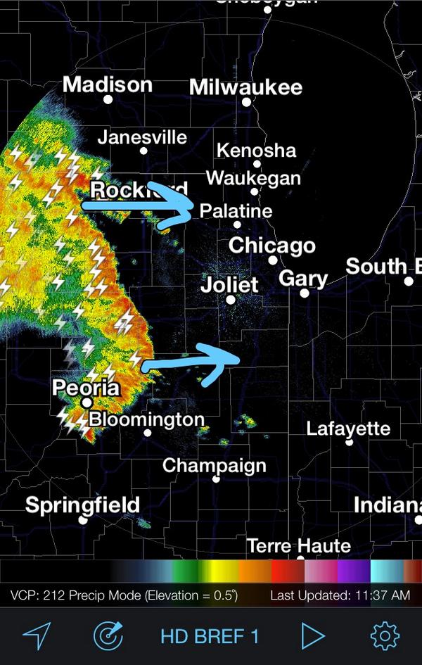
There is a major storm system over eastern Nebraska extending west to southern New Mexico that looks to be heading right in our direction. Looks like no game for me tonight.
http://chicagoweathercenter.com/radar |
|
|
|
|
Sep 5 2014, 09:47 AM
Post
#594
|
|
|
Spends WAY too much time at CBTL Group: Admin Posts: 16,423 Joined: 8-December 06 From: Michigan City, IN Member No.: 2 |
QUOTE(taxthedeer @ Sep 5 2014, 10:04 AM) There is a major storm system over eastern Nebraska extending west to southern New Mexico that looks to be heading right in our direction. Looks like no game for me tonight. http://chicagoweathercenter.com/radar Yeah this is looking like it might be a Saturday make up day. |
|
|
|
|
Sep 5 2014, 09:55 AM
Post
#595
|
|
|
Really Comfortable Group: Members Posts: 1,177 Joined: 19-November 09 Member No.: 969 |
Don't feel like it now.....at least not yet.
Alerts for La Porte County Number of Active Alerts: 1 Go to alert detail: 1 There is 1 active alert issued for La Porte County HEAT ADVISORY IN EFFECT UNTIL 6 PM EDT /5 PM CDT/ THIS EVENING Urgent - Weather Message National Weather Service Northern Indiana 1146 AM EDT Fri Sep 5 2014 La Porte-St. Joseph IN-Elkhart-Lagrange-Steuben-Noble-De Kalb- Starke-Pulaski-Marshall-Fulton IN-Kosciusko-Whitley-Allen IN- White-Cass IN-Miami-Wabash-Huntington-Wells-Adams-Grant-Blackford- Jay-Williams-Fulton OH-Defiance-Henry-Paulding-Putnam-Van Wert- Allen OH- Including The Cities Of, Michigan City, La Porte, South Bend, Mishawaka, New Carlisle, Walkerton, Elkhart, Goshen, Nappanee, Lagrange, Topeka, Shipshewana, Angola, Fremont, Kendallville, Ligonier, Albion, Auburn, Garrett, Knox, North Judson, Bass Lake, Winamac, Francesville, Medaryville, Plymouth, Bremen, Culver, Rochester, Akron, Warsaw, Winona Lake, Syracuse, Mentone, Columbia City, Tri-Lakes, South Whitley, Fort Wayne, New Haven, Monticello, Brookston, Monon, Logansport, Royal Center, Peru, Grissom Afb, Mexico, Wabash, North Manchester, Huntington, Roanoke, Bluffton, Ossian, Decatur, Berne, Marion, Gas City, Upland, Hartford City, Montpelier, Portland, Dunkirk, Bryan, Wauseon, Archbold, Fayette, Swanton, Defiance, Sherwood, Hicksville, Napoleon, Deshler, Liberty Center, Paulding, Antwerp, Melrose, Ottawa, Pandora, Kalida, Fort Jennings, Van Wert, Delphos, Ohio City, Lima, Spencerville 1146 AM EDT Fri Sep 5 2014 /1046 AM Cdt Fri Sep 5 2014/ , Heat Advisory IN Effect Until 6 PM EDT /5 PM Cdt/ This Evening, The National Weather Service IN Northern Indiana Has Issued A Heat Advisory, Which Is IN Effect Until 6 PM EDT /5 PM Cdt/ This Evening. Hazardous Weather, * The Heat Index Is Expected To Rise To Around 100 Degrees This Afternoon Over Northern Indiana And Northwest Ohio. Impacts, * The Combination Of Heat And Humidity Will Cause A Situation Where Heat Illness Is Possible. Precautionary/Preparedness Actions, A Heat Advisory Means That A Period Of Hot Temperatures Is Expected. The Combination Of Hot Temperatures And High Humidity Will Combine To Create A Situation IN Which Heat Illnesses Are Possible. Drink Plenty Of Fluids, Stay IN An Air-Conditioned Room, Stay Out Of The Sun, And Check Up On Relatives And Neighbors. Take Extra Precautions If You Work Or Spend Time Outside. When Possible, Reschedule Strenuous Activities To Early Morning Or Evening. Know The Signs And Symptoms Of Heat Exhaustion And Heat Stroke. Wear Light Weight And Loose Fitting Clothing When Possible And Drink Plenty Of Water. |
|
|
|
|
Sep 5 2014, 11:05 AM
Post
#596
|
|
|
Really Comfortable Group: Members Posts: 2,005 Joined: 6-July 09 From: In Front of a computer screen Member No.: 929 |
QUOTE(Southsider2k12 @ Sep 5 2014, 10:47 AM) Yeah this is looking like it might be a Saturday make up day. The team should not even bother loading the yellow submarines. Just postpone to 6PM tomorrow when it is going to be nice outside. Last week the Homestead @ Valpo game did not kickoff until 10:15PM. I actually drove from South Bend the Valparaiso High School to watch the first half of that game. The Hobart @ La Porte had to be called at the end of the 1st quarter then Hobart had to come back Saturday evening to resume and complete that game. |
|
|
|
|
Sep 5 2014, 12:02 PM
Post
#597
|
|
|
Advanced Member Group: Members Posts: 298 Joined: 18-March 14 Member No.: 1,324 |
I bet you they will still play tonight though, The storms are supposed to be out of here, by 6 or so, as I heard 3 to 6 PM is the time to watch the skies, and the'll wait until the last minute to postpone it. Thats what happend last week. LaPorte is the only game that had to be made up in the DAC last Saturday.
|
|
|
|
|
Sep 5 2014, 12:12 PM
Post
#598
|
|
|
Really Comfortable Group: Members Posts: 1,177 Joined: 19-November 09 Member No.: 969 |
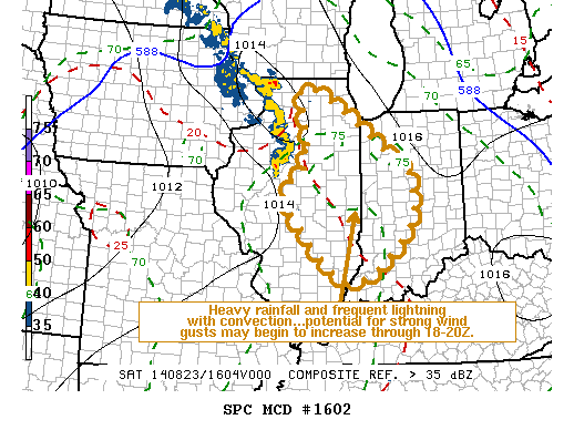
Guess the forecasters weren't joking: HEAT INDEX 101
Witch means watches, warnings and all that other nasty friggin weather stuff later on. |
|
|
|
|
Sep 5 2014, 01:27 PM
Post
#599
|
|
|
Really Comfortable Group: Members Posts: 1,177 Joined: 19-November 09 Member No.: 969 |
Couple of storm lines already forming out to the west. Batten down the hatches.
|
|
|
|
|
Sep 5 2014, 01:37 PM
Post
#600
|
|
|
Really Comfortable Group: Members Posts: 2,005 Joined: 6-July 09 From: In Front of a computer screen Member No.: 929 |
QUOTE(Michigan City Wolves @ Sep 5 2014, 01:02 PM) I bet you they will still play tonight though, The storms are supposed to be out of here, by 6 or so, as I heard 3 to 6 PM is the time to watch the skies, and the'll wait until the last minute to postpone it. Thats what happend last week. LaPorte is the only game that had to be made up in the DAC last Saturday. The game will be carried on wimsradio.com tonight. If the start of the game is delayed and they anoounce the teams are taking the field for warmups then I will head over to Chesterton. |
|
|
|
|
2 User(s) are reading this topic (2 Guests and 0 Anonymous Users)
0 Members:
| Lo-Fi Version | Time is now: 24th April 2024 - 05:51 PM |
Skin Designed By: neo at www.neonetweb.com
Invision Power Board
v2.1.7 © 2024 IPS, Inc.