
  |

 Feb 7 2018, 10:19 AM Feb 7 2018, 10:19 AM
Post
#1
|
|
 Spends WAY too much time at CBTL  Group: Admin Posts: 16,425 Joined: 8-December 06 From: Michigan City, IN Member No.: 2 |
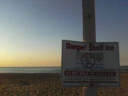
[/quote]Winter Storm Watch for La Porte County, Indiana
From 11:00pm CST, Thu Feb 8 until 11:00pm CST, Fri Feb 9 Action Recommended: Make preparations per the instructions Issued by: North Webster - IN, US, National Weather Service, ...WINTER STORM WATCH REMAINS IN EFFECT FROM LATE THURSDAY NIGHT THROUGH FRIDAY EVENING... * WHAT...Heavy snow of 5 to 9 inches possible. * WHERE...In Indiana, Noble and De Kalb Counties. In Ohio, Williams County. * WHEN...From late Thursday night through Friday evening. * ADDITIONAL DETAILS...Plan on difficult travel conditions, including during the morning and afternoon commutes on Friday. Significant reductions in visibility are possible. PRECAUTIONARY/PREPAREDNESS ACTIONS... A Winter Storm Watch means there is potential for significant snow, sleet or ice accumulations that may impact travel. Continue to monitor the latest forecasts. && [/quote] |
   |

 
|
|
Feb 7 2018, 11:44 AM
Post
#2
|
|
 Really Comfortable Group: Members Posts: 1,177 Joined: 19-November 09 Member No.: 969 |
Winter Storm Watch
URGENT - WINTER WEATHER MESSAGE National Weather Service Northern Indiana 959 AM EST Wed Feb 7 2018 INZ003>005-008-009-012-014-016-MIZ077>079-OHZ001-002-072100- /O.CON.KIWX.WS.A.0003.180209T0500Z-180210T0500Z/ La Porte-St. Joseph IN-Elkhart-Noble-De Kalb-Starke-Marshall- Kosciusko-Berrien-Cass MI-St. Joseph MI-Williams-Fulton OH- Including the cities of Michigan City, La Porte, South Bend, Mishawaka, New Carlisle, Walkerton, Elkhart, Goshen, Nappanee, Kendallville, Ligonier, Albion, Auburn, Garrett, Knox, North Judson, Bass Lake, Plymouth, Bremen, Culver, Warsaw, Winona Lake, Syracuse, Mentone, Niles, Benton Harbor, St. Joseph, Fair Plain, Benton Heights, Buchanan, Paw Paw Lake, Dowagiac, Cassopolis, Marcellus, Sturgis, Three Rivers, White Pigeon, Mendon, Bryan, Montpelier, Edgerton, Wauseon, Archbold, Swanton, and Delta 959 AM EST Wed Feb 7 2018 /859 AM CST Wed Feb 7 2018/ ...WINTER STORM WATCH REMAINS IN EFFECT FROM LATE THURSDAY NIGHT THROUGH FRIDAY EVENING... * WHAT...Heavy snow of 5 to 9 inches possible. * WHERE...In Indiana, Noble and De Kalb Counties. In Ohio, Williams County. * WHEN...From late Thursday night through Friday evening. * ADDITIONAL DETAILS...Plan on difficult travel conditions, including during the morning and afternoon commutes on Friday. Significant reductions in visibility are possible. PRECAUTIONARY/PREPAREDNESS ACTIONS... A Winter Storm Watch means there is potential for significant snow, sleet or ice accumulations that may impact travel. Continue to monitor the latest forecasts. |
|
|
|
|
Feb 8 2018, 10:32 AM
Post
#3
|
|
|
Spends WAY too much time at CBTL Group: Admin Posts: 16,425 Joined: 8-December 06 From: Michigan City, IN Member No.: 2 |
Now up to a warning. Time For #CantoreWatch
|
|
|
|
|
Feb 8 2018, 11:19 AM
Post
#4
|
|
|
Really Comfortable Group: Members Posts: 1,177 Joined: 19-November 09 Member No.: 969 |
Predictions are all over the place: 10"? 12"? 14"? Its still quite a shovel full.
|
|
|
|
|
Feb 15 2018, 01:04 PM
Post
#5
|
|
|
Really Comfortable Group: Members Posts: 1,177 Joined: 19-November 09 Member No.: 969 |
UPDATE: Dense fog advisory extended through Thursday afternoon Times Staff Feb 15, 2018 Updated 2 hrs ago The National Weather Service has extended a dense fog advisory for much of Northwest Indiana through Thursday afternoon. Some of the lowest visibility was expected along the Interstate 80 corridor in Lake and Porter counties. A dense fog advisory for Lake, Porter, LaPorte Newton and Jasper counties is now in effect until 4 p.m. It's possible fog in some areas may persist until afternoon, forecasters said. Several schools announced closings and delays because of the fog. Indiana State Police for the Toll Road said two people were taken to hospitals Thursday morning after a semi jackknifed on westbound Interstate 90, just east of the Cline Avenue exit in Gary. The tollway was backed up for hours as police investigated and crews cleaned up. Troopers had not yet determined if the fog was a factor in the crash, police said. Indiana State Police for the Lowell post responded to a crash involving an overturned semi on southbound Interstate 65, south of the Ind. 2 exit near Lowell. Drivers should avoid the area because of a long backup, the Indiana Department of Transportation's Northwest District said. Visibility could be reduced to a quarter mile or less and could change rapidly in some areas, forecasters said. LaPorte and Jasper counties were under a travel advisory, which means routine travel may be affected because of hazardous conditions, according to the Indiana Department of Homeland Security. Drivers should slow down, turn on headlights, avoid following too closely and allow extra time for travel. |
|
|
|
|
Feb 17 2018, 06:55 AM
Post
#6
|
|
|
Really Comfortable Group: Members Posts: 1,177 Joined: 19-November 09 Member No.: 969 |
Hydrologic Outlook
Hydrologic Outlook INC001-003-009-017-033-039-049-053-069-075-085-087-091-099-103- 113-131-141-149-151-169-179-181-183-MIC021-023-027-059-149-OHC003- 039-051-069-125-137-161-171-181015- Adams-Allen IN-Blackford-Cass IN-De Kalb-Elkhart-Fulton IN-Grant- Huntington-Jay-Kosciusko-Lagrange-La Porte-Marshall-Miami-Noble- Pulaski-St. Joseph IN-Starke-Steuben-Wabash-Wells-White-Whitley- Berrien-Branch-Cass MI-Hillsdale-St. Joseph MI-Allen OH-Defiance- Fulton OH-Henry-Paulding-Putnam-Van Wert-Williams- Hydrologic Outlook National Weather Service Northern Indiana 503 AM EST Sat Feb 17 2018 /403 AM CST Sat Feb 17 2018/ ...Elevated Risk of River Flooding this Upcoming Week... The combination of recent rainfall, saturated ground and upcoming rounds of rain will lead to the potential for flooding on area streams and rivers over the next week. Areal flooding is also possible, particularly over low lying and other flood prone areas. Rainfall amounts between 1 and 4 inches could fall between Monday and Wednesday. Additional rainfall is possible toward the end of the week as well. There is still some uncertainty as to where the heaviest rainfall will occur. If you live along streams and rivers or in any flood prone area, remain alert to this flooding potential over the next week. Listen to NOAA Weather All Hazards Radio or other sources for the latest forecast information. |
|
|
|
|
2 User(s) are reading this topic (2 Guests and 0 Anonymous Users)
0 Members:
| Lo-Fi Version | Time is now: 25th April 2024 - 09:23 PM |
Skin Designed By: neo at www.neonetweb.com
Invision Power Board
v2.1.7 © 2024 IPS, Inc.