
  |

 Feb 29 2016, 06:27 PM Feb 29 2016, 06:27 PM
Post
#701
|
|
 Member  Group: Members Posts: 93 Joined: 15-February 14 Member No.: 1,319 |
Will the Silly SOB what is in charge of the weather give it up....It's time for Spring already.
|
   |

 
|
|
Mar 2 2016, 08:11 AM
Post
#702
|
|
 Really Comfortable Group: Members Posts: 1,177 Joined: 19-November 09 Member No.: 969 |
 Might see the 80s by Easter.  _ |
|
|
|
|
Mar 9 2016, 08:18 AM
Post
#703
|
|
|
Really Comfortable Group: Members Posts: 1,177 Joined: 19-November 09 Member No.: 969 |
 Almost felt like July yesterday with that sun out there. |
|
|
|
|
Mar 15 2016, 06:53 AM
Post
#704
|
|
|
Really Comfortable Group: Members Posts: 1,177 Joined: 19-November 09 Member No.: 969 |
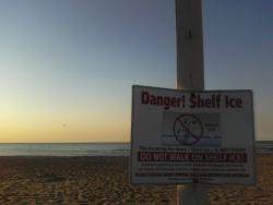
 Stay off the big lake and piers tomorrow.  |
|
|
|
|
Mar 26 2016, 09:41 AM
Post
#705
|
|
|
Really Comfortable Group: Members Posts: 1,177 Joined: 19-November 09 Member No.: 969 |
|
|
|
|

|
Mar 31 2016, 11:51 AM
Post
#706
|
|
|
Really Comfortable Group: Members Posts: 1,177 Joined: 19-November 09 Member No.: 969 |
 Get ready. |
|
|
|
|
Apr 3 2016, 01:22 PM
Post
#707
|
|
|
Really Comfortable Group: Members Posts: 1,177 Joined: 19-November 09 Member No.: 969 |
 Wind Advisory Counties affected: Cass; Elkhart; Fulton; Grant; Kosciusko; La Porte; Marshall; Miami; Pulaski; St. Joseph; Starke; Wabash; White Expires 8:00 PM on Sunday, April 3rd 2016 Wind Advisory issued April 03 at 12:17PM EDT until April 03 at 8:00PM EDT by NWS NorthernIndiana ...WIND ADVISORY REMAINS IN EFFECT UNTIL 8 PM EDT /7 PM CDT/ THIS EVENING... HAZARDOUS WEATHER... * SOUTHWEST 25 TO 35 MPH WITH GUSTS OF 40 TO 45 MPH THIS AFTERNOON. IMPACTS... * DRIVING HIGH PROFILE VEHICLES MAY BE DIFFICULT. * SCATTERED TREE AND POWER LINE DAMAGE IS POSSIBLE. |
|
|
|
|
Apr 4 2016, 10:09 AM
Post
#708
|
|
 Spends WAY too much time at CBTL Group: Admin Posts: 16,421 Joined: 8-December 06 From: Michigan City, IN Member No.: 2 |
It was crazy driving through those winds on the interstate yesterday.
|
|
|
|
|
Apr 4 2016, 12:23 PM
Post
#709
|
|
|
Really Comfortable Group: Members Posts: 1,177 Joined: 19-November 09 Member No.: 969 |
|
|
|
|
|
Apr 6 2016, 06:48 AM
Post
#710
|
|
|
Really Comfortable Group: Members Posts: 1,177 Joined: 19-November 09 Member No.: 969 |
 You gotta believe. |
|
|
|
|
Apr 11 2016, 07:11 AM
Post
#711
|
|
|
Really Comfortable Group: Members Posts: 1,177 Joined: 19-November 09 Member No.: 969 |
 Well its about time.  _ |
|
|
|
|
Apr 11 2016, 08:07 AM
Post
#712
|
|
|
Spends WAY too much time at CBTL Group: Admin Posts: 16,421 Joined: 8-December 06 From: Michigan City, IN Member No.: 2 |
So how cold has been been in Michigan City lately? How is this for a comparison.
Thursday through Sunday the high temps in Michigan City have been 41, 39, 32, and 50, respectively. In Anchorage Alaska the highs from Thursday to Sunday were 54, 53, 42, and 55. Even better the forecast here shows it is supposed to be 47 today, 41 tomorrow and 55 on Wednesday in Michigan City. In Anchorage? 51 today, 55 tomorrow, and 55 on Wednesday. We could be looking at a week straight of it being warming in Alaska, versus Michigan City. |
|
|
|
|
Jun 10 2016, 12:16 PM
Post
#713
|
|
|
Really Comfortable Group: Members Posts: 1,177 Joined: 19-November 09 Member No.: 969 |
 Hot damn...AMAZON weather is here now ! _ |
|
|
|
|
Jun 21 2016, 06:42 AM
Post
#714
|
|
|
Really Comfortable Group: Members Posts: 1,177 Joined: 19-November 09 Member No.: 969 |
 We're under the GUN tomorrow. Heads up Be prepared for Wednesday- Significant severe weather threat shaping up for the Chicago area tomorrow by Steve Kahn Today at 7AM The Storm Prediction Center in Norman, Oklahoma has placed the entire Chicago area in an area of moderate risk for severe weather. The potential scenario at this time indicates the possibility of two rounds of significant thunderstorm activity. The first round will occur during the morning as a warm front lifts north through Illinois. Thunderstorms with large hail and heavy rainfall will be the primary hazards with a low risk of damaging wind and tornadoes. The second and greater threat will be during the afternoon and evening as low-pressure approaches from the west along the warm frontal boundary. This could initiate rapid development of severe thunderstorms that could be accompanied by damaging winds and tornadoes. It is possible that a derecho, a long-lasting and rapidly-moving complex of severe thunderstorms could sweep across this area. At this time, awareness of the severe storm potential is key so plans of action can be readied if needed. |
|
|
|
|
Jun 22 2016, 08:55 AM
Post
#715
|
|
|
Really Comfortable Group: Members Posts: 1,177 Joined: 19-November 09 Member No.: 969 |
 Storms in LP yesterday...when there weren't even any clouds ? Is that possible ?? _ |
|
|
|
|
Jun 22 2016, 09:22 AM
Post
#716
|
|
|
Spends WAY too much time at CBTL Group: Admin Posts: 16,421 Joined: 8-December 06 From: Michigan City, IN Member No.: 2 |
There were clouds. There was a pretty intense and brief storm that moved through midday.
|
|
|
|
|
Jun 22 2016, 09:46 AM
Post
#717
|
|
|
Really Comfortable Group: Members Posts: 1,177 Joined: 19-November 09 Member No.: 969 |
 Guess it was just a taste and a preview of the main SHTF super cellular event...thats due later this evening for us: http://bit.ly/28Q5gCk _ |
|
|
|
|
Aug 11 2016, 06:29 AM
Post
#718
|
|
|
Really Comfortable Group: Members Posts: 1,177 Joined: 19-November 09 Member No.: 969 |
 Geez, when will MC ever see one of these ? QUOTE New photos from our WGN-TV west cam on top of Willis Tower of Tuesday’s 10 minute, lake-breeze-induced “landspout” tornado over Midway Airport–the city’s first twister since the Loyola University shoreline touchdown on the North Side Sept. 22, 2006 http://bit.ly/2bhPXlZ _ |
|
|
|
|
Aug 16 2016, 07:59 AM
Post
#719
|
|
|
Really Comfortable Group: Members Posts: 1,177 Joined: 19-November 09 Member No.: 969 |
Heavy rains/flooding south of Chicago in Illinois across northern Indiana – rainfall totals in excess of 8-inches in Indiana by Paul Dailey Today at 7AM ...A FLOOD WARNING REMAINS IN EFFECT UNTIL 1115 AM CDT TUESDAY FOR NORTHERN IROQUOIS...KANKAKEE IN ILLINOIS...NORTHERN JASPER...PORTER... LAKE AND NORTHERN NEWTON COUNTIES...AS WELL AS COUNTIES FARTHER EAST ACROSS NORTHERN INDIANA... HEAVY RAINFALL MONDAY EVENING PRODUCED AMOUNTS IN EXCESS OF 4 INCHES ACROSS PORTIONS OF THE WARNED AREA. WITH ANOTHER PERIOD OF LIGHT TO MODERATE RAIN EXPECTED OVERNIGHT...AREAL FLOODING WILL LIKELY CONTINUE THIS TUESDAY MORNING. FOLLOWING ARE SOME OF THE HIGHER RAINFALL AMOUNTS REPORTED... IN ILLINOIS JUST SOUTH OF CHICAGO... 4.75-INCHES MOMENCE, KANKAKEE COUNTY 4.41-INCHES KANKAKEE IN KANKAKEE COUNTY 4.14-INCHES ASHKUM, IROQUOIS COUNTY 4.10-INCHES CHEBANSE, KANKAKEE COUNTY 3.59-INCHES WATSEKA, IROQUOIS COUNTY NORTHWEST INDIANA... 4.72-INCHES RENSSELAER, LAKE COUNTY 4.46-INCHES WINFIELD, LAKE COUNTY 4.34-INCHES VALPARAISO, PORTER COUNTY 4.31-INCHES WHEATFIELD, JASPER COUNTY 3.97-INCHES SCHNEIDER, LAKE COUNTY 3.70-INCHES DEMOTTE, JASPER COUNTY 3.65-INCHES PORTAGE, PORTER COUNTY 3.13-INCHES KENTLAND, NEWTON COUNTY GREATEST RAINFALL APPEARED TO FALL JUST FARTHER EAST IN LAPORTE AND ST.JOSEPH COUNTIES IN NORTHERN INDIANA WHERE OVER 8-INCHES FELL...SOME REPORTS FROM THAT AREA... 8.95-INCHES WALKERTON, ST. JOSEPH COUNTY 8.48-INCHES GRANGER, ST. JOSEPH COUNTY 7.74-INCHES MISHAWAKA, ST. JOSEPH COUNTY 7.73-INCHES SOUTH BEND, ST.JOSEPH COUNTY 5.27-INCHES LAPORTE IN LAPORTE COUNTY |
|
|
|
|
Aug 16 2016, 08:58 AM
Post
#720
|
|
|
Spends WAY too much time at CBTL Group: Admin Posts: 16,421 Joined: 8-December 06 From: Michigan City, IN Member No.: 2 |
According to Weather Underground we got 3.60 inches at the airport.
|
|
|
|
|
1 User(s) are reading this topic (1 Guests and 0 Anonymous Users)
0 Members:
| Lo-Fi Version | Time is now: 19th April 2024 - 03:59 PM |
Skin Designed By: neo at www.neonetweb.com
Invision Power Board
v2.1.7 © 2024 IPS, Inc.