
  |

 Jul 1 2015, 11:26 AM Jul 1 2015, 11:26 AM
Post
#641
|
|
 Really Comfortable  Group: Members Posts: 1,177 Joined: 19-November 09 Member No.: 969 |
 No way you'll be able to sing this song today thats fer sure: "Blue skies smilin' at me Nothin' but blue skies do I see http://bit.ly/1ItqpxL _ |
   |

 
|
|
Jul 7 2015, 04:20 PM
Post
#642
|
|
|
Really Comfortable Group: Members Posts: 1,177 Joined: 19-November 09 Member No.: 969 |
 Perhaps the dune dunces have finally learned their lesson. Haven't heard much about riptide drownings this summer yet. _ |
|
|
|
|
Jul 8 2015, 12:58 PM
Post
#643
|
|
|
Really Comfortable Group: Members Posts: 1,177 Joined: 19-November 09 Member No.: 969 |
 Hey....how's everyone lovin and livin in Northern Canada here this week ?? Suppose to warm up this weekend i heard. _ |
|
|
|
|
Jul 10 2015, 07:06 AM
Post
#644
|
|
|
Really Comfortable Group: Members Posts: 1,177 Joined: 19-November 09 Member No.: 969 |
 Guess summer arrives this weekend. _ |
|
|
|
|
Jul 10 2015, 09:30 AM
Post
#645
|
|
 Spends WAY too much time at CBTL Group: Admin Posts: 16,425 Joined: 8-December 06 From: Michigan City, IN Member No.: 2 |
Apparently not in Michigan City!
|
|
|
|
|
Jul 12 2015, 04:31 AM
Post
#646
|
|
|
Really Comfortable Group: Members Posts: 1,177 Joined: 19-November 09 Member No.: 969 |
|
|
|
|

|
Jul 13 2015, 05:17 AM
Post
#647
|
|
|
Really Comfortable Group: Members Posts: 1,177 Joined: 19-November 09 Member No.: 969 |
 The beginning of what could be....a ROCKY MONDAY  |
|
|
|
|
Jul 13 2015, 06:30 AM
Post
#648
|
|
|
Really Comfortable Group: Members Posts: 1,177 Joined: 19-November 09 Member No.: 969 |
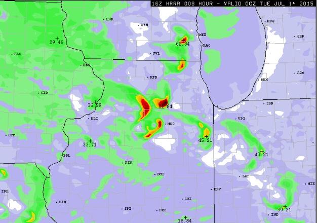
 Dangerous Thunderstorm Alert Earth Networks-WeatherBug Headquarters Germantown, MD 724 AM CDT Mon Jul 13 2015 WeatherBug-Earth Networks has issued a, * Dangerous Thunderstorm Alert (DTA) for portions of, LaPorte County In Indiana Porter County In Indiana St. Joseph County In Indiana Starke County In Indiana Berrien County In Michigan * Valid until 8:09AM CDT * At 7:24AM CDT, The WeatherBug-Earth Networks Early Warning System has detected a thunderstorm with a significant rate of lightning occurring in your area. It is moving in your direction. This storm has an increased potential to produce severe weather such as frequent lightning, heavy rain, hail and/or damaging winds and should be considered dangerous. Seek shelter now. (For more information on our Dangerous Thunderstorm Alerts visit WDTA.WeatherBug.com) * Storm is located near Beverly Shores, IN * Locations impacted include, Beverly Shores, IN, at 7:45AM CDT Chesterton, IN, at 7:45AM CDT Michigan City, IN, at 7:49AM CDT Westville, IN, at 7:54AM CDT La Porte, IN, at 8:01AM EST * Peak wind gusts in vicinity, Highland, IN, Highland HS, W 35 mph at 7:21AM CDT Calumet City, IL, Lincoln ES, WNW 46 mph at 7:20AM CDT Minooka, IL, Minooka JHS, NE 35 mph at 7:19AM CDT Hammond, IN, Hammond Schools, W 49 mph at 7:17AM CDT Homewood, IL, St Joseph School, NW 31 mph at 7:17AM CDT * Peak rain rates in vicinity, Palos Heights, IL, Elim Christian Services, 1.04 "/hr at 7:22AM CDT Tinley Park, IL, Trinity Lutheran School, 0.56 "/hr at 7:22AM CDT Palos Heights, IL, Chicago Christian High School, 1.04 "/hr at 7:21AM CDT Blue Island, IL, Dwight D. Eisenhower HS, 0.84 "/hr at 7:21AM CDT Chicago, IL, The Salvation Army Kroc Center Chicago, 0.92 "/hr at 7:21AM CDT * Take appropriate measures to insure safety to life and property immediately. |
|
|
|
|
Jul 13 2015, 08:09 AM
Post
#649
|
|
|
Spends WAY too much time at CBTL Group: Admin Posts: 16,425 Joined: 8-December 06 From: Michigan City, IN Member No.: 2 |
That was a fun wake up call this morning.
|
|
|
|
|
Jul 13 2015, 12:16 PM
Post
#650
|
|
|
Really Comfortable Group: Members Posts: 1,177 Joined: 19-November 09 Member No.: 969 |
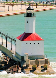
 Kudos to Robert Quinn for this awesome MC shot !  _ |
|
|
|
|
Jul 13 2015, 03:58 PM
Post
#651
|
|
|
Really Comfortable Group: Members Posts: 1,177 Joined: 19-November 09 Member No.: 969 |
 Sunlight daytime heating, high humidity and dew point levels combined with an active potent geocosmic shock window, an you have yourself a super cellular shitstorm development. Get ready for watches, warnings and whatnot. _ |
|
|
|
|
Jul 13 2015, 06:47 PM
Post
#652
|
|
|
Really Comfortable Group: Members Posts: 1,177 Joined: 19-November 09 Member No.: 969 |
 Rough nite for LP County ahead. |
|
|
|
|
Jul 15 2015, 08:25 AM
Post
#653
|
|
|
Spends WAY too much time at CBTL Group: Admin Posts: 16,425 Joined: 8-December 06 From: Michigan City, IN Member No.: 2 |
The north winds made for amazing wave action last night.
|
|
|
|
|
Jul 15 2015, 05:07 PM
Post
#654
|
|
|
Really Comfortable Group: Members Posts: 1,177 Joined: 19-November 09 Member No.: 969 |
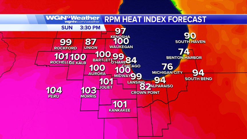
QUOTE(Southsider2k12 @ Jul 15 2015, 09:25 AM)  The north winds made for amazing wave action last night. Approaching 70 degrees lake water temp. Beaches should be PACKED this weekend with 100+ heat index. Any riptide warnings...will be IGNORED |
|
|
|
|
Jul 16 2015, 07:22 AM
Post
#655
|
|
|
Really Comfortable Group: Members Posts: 1,177 Joined: 19-November 09 Member No.: 969 |
 Anybody wishing for a little summer like heat soon...will get it in SPADES this weekend. |
|
|
|
|
Jul 16 2015, 09:42 AM
Post
#656
|
|
|
Spends WAY too much time at CBTL Group: Admin Posts: 16,425 Joined: 8-December 06 From: Michigan City, IN Member No.: 2 |
QUOTE(diggler @ Jul 16 2015, 08:22 AM) Anybody wishing for a little summer like heat soon...will get it in SPADES this weekend. Apparently cooler by the lake will be in vogue this weekend. |
|
|
|
|
Jul 17 2015, 06:27 AM
Post
#657
|
|
|
Really Comfortable Group: Members Posts: 1,177 Joined: 19-November 09 Member No.: 969 |
 Noble intentions, but with a forecast like this tomorrow....you gotta start wondering. QUOTE Don’t be confused if you hear bells Saturday, July 18, but do reach for your wallet. The LaPorte Salvation Army will once again conduct its Christmas in July kettle campaign http://bit.ly/1KcjsTl QUOTE LA PORTE — The weather may not feel like it, but it's summer and even though Christmas may be far from many people's minds, the season of giving is looking for a brief resurgence this July. http://bit.ly/1RDvngY _ |
|
|
|
|
Jul 18 2015, 05:59 AM
Post
#658
|
|
|
Really Comfortable Group: Members Posts: 1,177 Joined: 19-November 09 Member No.: 969 |
 Heat Advisory remains in effect from 10AM CDT until 8PM CDT for the entire Chicago area Saturday by Paul Dailey Today at 5AM ...HEAT ADVISORY REMAINS IN EFFECT FROM 10 AM THIS MORNING TO 8 PM CDT THIS EVENING FOR NORTHEAST ILLINOIS AND NORTHWEST INDIANA INCLUDING THE CITY OF CHICAGO... * HIGH TEMPERATURES...MIDDLE 90S. * PEAK HEAT INDICES...105 TO 110 DEGREES. * IMPACTS...THE COMBINATION OF HEAT AND HUMIDITY WILL CREATE OPPRESSIVE CONDITIONS WHICH MAY CAUSE HEAT RELATED ILLNESSES TO DEVELOP DUE TO PROLONGED EXPOSURE...PARTICULARLY THE ELDERLY AND THOSE WITH PRE-EXISTING HEALTH CONDITIONS. FOR HEAT RELATED SERVICES WITHIN THE CITY OF CHICAGO...INCLUDING REQUESTING WELL BEING CHECKS...DIAL 3 1 1. PRECAUTIONARY/PREPAREDNESS ACTIONS... TAKE EXTRA PRECAUTIONS...IF YOU WORK OR SPEND TIME OUTSIDE. WHEN POSSIBLE...RESCHEDULE STRENUOUS ACTIVITIES TO EARLY MORNING OR EVENING. KNOW THE SIGNS AND SYMPTOMS OF HEAT EXHAUSTION AND HEAT STROKE. WEAR LIGHT WEIGHT AND LOOSE FITTING CLOTHING WHEN POSSIBLE AND DRINK PLENTY OF WATER. TO REDUCE RISK DURING OUTDOOR WORK...THE OCCUPATIONAL SAFETY AND HEALTH ADMINISTRATION RECOMMENDS SCHEDULING FREQUENT REST BREAKS IN SHADED OR AIR CONDITIONED ENVIRONMENTS. ANYONE OVERCOME BY HEAT SHOULD BE MOVED TO A COOL AND SHADED LOCATION. HEAT STROKE IS AN EMERGENCY...CALL 9 1 1. A HEAT ADVISORY MEANS THAT A PERIOD OF HOT WEATHER IS EXPECTED. HIGH TEMPERATURES AND HIGH HUMIDITY WILL COMBINE TO CREATE A SITUATION IN WHICH HEAT ILLNESSES ARE POSSIBLE. DRINK PLENTY OF FLUIDS...STAY IN AN AIR-CONDITIONED ROOM...STAY OUT OF THE SUN... AND CHECK UP ON RELATIVES AND NEIGHBORS. CHILDREN AND PETS SHOULD NEVER BE LEFT UNATTENDED IN VEHICLES UNDER ANY CIRCUMSTANCES. THIS IS ESPECIALLY TRUE DURING HOT WEATHER WHEN THE CAR INTERIOR CAN REACH LETHAL TEMPERATURES IN A MATTER OF MINUTES! |
|
|
|
|
Jul 18 2015, 01:13 PM
Post
#659
|
|
|
Really Comfortable Group: Members Posts: 1,177 Joined: 19-November 09 Member No.: 969 |
 URGENT – IMMEDIATE BROADCAST REQUESTED TORNADO WATCH NUMBER 436 NWS STORM PREDICTION CENTER NORMAN OK 130 PM CDT SAT JUL 18 2015 THE NWS STORM PREDICTION CENTER HAS ISSUED A * TORNADO WATCH FOR PORTIONS OF FAR EASTERN IOWA NORTHERN ILLINOIS NORTHWEST INDIANA SOUTHERN AND EASTERN WISCONSIN LAKE MICHIGAN * EFFECTIVE THIS SATURDAY AFTERNOON AND EVENING FROM 130 PM UNTIL 1000 PM CDT. * PRIMARY THREATS INCLUDE… A FEW TORNADOES POSSIBLE SCATTERED DAMAGING WIND GUSTS TO 70 MPH LIKELY SCATTERED LARGE HAIL AND ISOLATED VERY LARGE HAIL EVENTS TO 2 INCHES IN DIAMETER POSSIBLE SUMMARY…THUNDERSTORMS EXPECTED TO INCREASE IN COVERAGE/STRENGTH OVER SOUTHERN WI OVER THE NEXT COUPLE HOURS…WITH OTHER DEVELOPMENT POSSIBLE LATER THIS AFTERNOON OVER FAR EASTERN IA AND NORTHERN IL. POTENTIAL WILL EXIST FOR SUPERCELLS WITH DAMAGING WIND…HAIL…AND POSSIBLY A FEW TORNADOES THROUGH EARLY TONIGHT…WITH THE TORNADO THREAT GREATEST OVER SOUTHERN/EASTERN WI AND NORTHERN IL THIS AFTERNOON. THE TORNADO WATCH AREA IS APPROXIMATELY ALONG AND 85 STATUTE MILES NORTH AND SOUTH OF A LINE FROM 50 MILES SOUTH SOUTHWEST OF LONEROCK WISCONSIN TO 50 MILES NORTH NORTHEAST OF VALPARAISO INDIANA. FOR A COMPLETE DEPICTION OF THE WATCH SEE THE ASSOCIATED WATCH OUTLINE UPDATE (WOUS64 KWNS WOU6). PRECAUTIONARY/PREPAREDNESS ACTIONS… REMEMBER…A TORNADO WATCH MEANS CONDITIONS ARE FAVORABLE FOR TORNADOES AND SEVERE THUNDERSTORMS IN AND CLOSE TO THE WATCH AREA. PERSONS IN THESE AREAS SHOULD BE ON THE LOOKOUT FOR THREATENING WEATHER CONDITIONS AND LISTEN FOR LATER STATEMENTS AND POSSIBLE WARNINGS. |
|
|
|
|
Jul 20 2015, 05:20 AM
Post
#660
|
|
|
Really Comfortable Group: Members Posts: 1,177 Joined: 19-November 09 Member No.: 969 |
 "Just a few of the smiling faces from our volunteer bell ringers in front of Al's. Thank you for braving this heat to help the Salvation Army for Christmas in July!" |
|
|
|
|
1 User(s) are reading this topic (1 Guests and 0 Anonymous Users)
0 Members:
| Lo-Fi Version | Time is now: 26th April 2024 - 01:31 AM |
Skin Designed By: neo at www.neonetweb.com
Invision Power Board
v2.1.7 © 2024 IPS, Inc.